Midday Nowcast: A Wet and Stormy Monday for Alabama
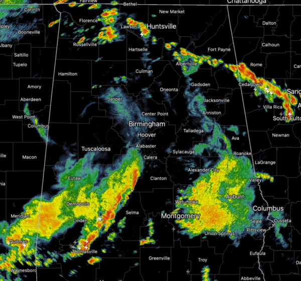
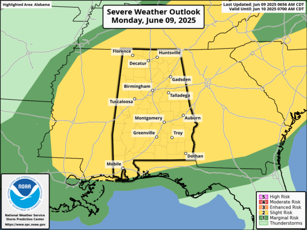
WET AND STORMY MONDAY: The SPC maintains all of Alabama in a “slight risk” (level 2/5) of severe thunderstorms today. It has been a wet and stormy this morning, and storms will continue to be a threat through the afternoon and evening hours. Stronger storms will be capable of producing strong, gusty winds and hail, and there is a non-zero tornado threat.
Temperatures this afternoon are in the 70s and 80s due to the clouds and rain. Additionally, storms are producing lots of lightning and heavy rainfall and areas of isolated flash flooding are possible.
BIRMINGHAM ALMANAC: For June 9th, the average high for Birmingham is 87° and the average low is 67°. The record high is 98° set in 1898, while the record low is 52° set in 1931. We average 0.16” of precipitation on this date and the record value is 1.42” set in 2013.
LOWER RAIN CHANCES: Finally a break in the widespread rain and storms as rain chances trend downward the next couple of days and it will be more of a typical early June weather pattern for Alabama, as showers and storms will be fewer in number, and more widely spaced. Chance of any one spot getting wet tomorrow and Wednesday will be in the 20-40% range. Afternoon highs will be in the mid 80s.
RAIN CHANCES CLIMB AGAIN: Rain chances increase to the 50-60% rain for Thursday and Friday. Expect scattered, mostly afternoon/evening showers and storms with afternoon highs in the upper 80s.
THE WEEKEND: Unfortunately, rain chances will be higher again for the weekend. Expect very warm, humid days, and a partly sunny sky, with scattered to numerous showers ands storms. Rain chances look to be in the 70-80% range with the greatest coverage of storms during the afternoon and evening hours, 2PM-10PM. Afternoon highs will be in the upper 80s in most spots.
IN THE TROPICS: All is quiet and no tropical storm or hurricane development is expected in the Gulf of Mexico, Caribbean Sea, or the rest of the Atlantic the next seven days.
WORLD TEMPERATURE EXTREMES: Over the last 24 hours, the highest observation outside the U.S. was 119.1F at Jacobabad, Pakistan. The lowest observation was -102.3F at Vostok, Antarctica.
CONTIGUOUS TEMPERATURE EXTREMES: Over the last 24 hours, the highest observation was 116F at Death Valley, CA. The lowest observation was 26F at Peter Sinks, UT and Foxpark, WY.
Category: Alabama's Weather, ALL POSTS, Social Media
About the Author (Author Profile)
Macon, Georgia Television Chief Meteorologist, Birmingham native, and long time Contributor on AlabamaWX. Stormchaser. I did not choose Weather, it chose Me. College Football Fanatic. @Ryan_StinnetSubscribe
If you enjoyed this article, subscribe to receive more just like it.


