Midday Nowcast: Muggy Days with Scattered Strong Storms
AIR YOU CAN WEAR: Well I made it back to Birmingham late last night from an incredible trip to Boise for the 52nd annual American Meteorological Society’s Broadcast Meteorology Conference. It was a great conference full of us weather weenies, where we talk and learn about what we love…the weather. If you have never been to Boise, I highly recommend it! It is beautiful, very clean, and the air is extra fresh, and of course no humidity. This first thing I noticed upon arrival back in Birmingham was the weight of the very humid air. That humidity remains a key part of our forecast.
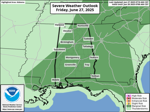
Heat Advisories continue today for the Tennessee Valley of the state, where heat index values today will be in the 105°-108° range. For the rest of Alabama, it will continue to be hot and humid. Big HEAT, Big STORMS, and yet again today, due to the high instability values across the state, the Storm Prediction Center has much of Alabama in a severe weather risk both today.
When and where afternoon and evening storms develop they will likely produce strong, gusty winds and hail. Of course, all summer storms produce frequent and dangerous lightning (WHEN THUNDER ROARS, HEAD INDOORS), along with intense, tropical downpours, which can lead to areas of isolated flash flooding (TURN AROUND, DONT’ DROWN).
BIRMINGHAM ALMANAC: For June 27th, the average high for Birmingham is 90° and the average low is 71°. The record high is 102° set in 1954, while the record low is 53° set in 1974. We average 0.17” of precipitation on this date and the record value is 1.80” set in 1926.
ACROSS THE USA: The prolonged and intense heat wave continues today for portions of the Ohio Valley and Mid-Atlantic, with relief expected by this weekend. There will be daily chances for severe thunderstorms and heavy rainfall in the northern Plains and Upper Midwest today through Sunday.
WEEKEND WEATHER: There will be an increase in the number of afternoon/evening showers and thunderstorms, and slightly lower heat levels. Highs will be generally in the mid to upper 80s with a few lower 90s. Expect a partly sunny sky with higher rain chances both days in the 50-60% range.
NEXT WEEK: Monday and Tuesday will have widespread rain and storms at times as rain chances will be in 70-90% range with highs in the mid to upper 80s. As we approach the Independence Day weekend, highs will climb closer to the low 90s, which are pretty close to average for early July in Alabama. There will still be rain chances in the 50-60% range, and most of the rain and storms will come during the afternoon and evening hours. Overall fairly routine weather for Alabama to end June and start July.
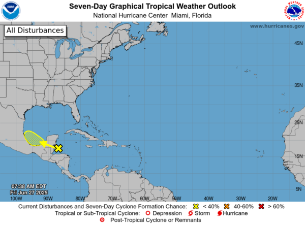
IN THE TROPICS: For the Bay of Campeche in the southwestern Gulf, an area of disorganized showers and thunderstorms over the northwestern Caribbean sea and the adjacent land areas is expected to move west-northwestward into the Bay of Campeche Saturday or Saturday night, where an area of low pressure could form. Subsequent development is possible on Sunday or Monday if the system remains offshore of the coast of Mexico. Regardless of development, locally heavy rains are possible over portions of Belize, Guatemala, and southeastern Mexico during the next few days. Formation chance through 48 hours…low…10 percent. Formation chance through 7 days…low…20 percent. The rest of the Atlantic Basin is quiet.
WORLD TEMPERATURE EXTREMES: Over the last 24 hours, the highest observation outside the U.S. was 117.0F at Kuwait International Airport, Kuwait. The lowest observation was -103.9F at Vostok, Antarctica.
CONTIGUOUS TEMPERATURE EXTREMES: Over the last 24 hours, the highest observation was 115F at Death Valley, CA. The lowest observation was 27F at Peter Sinks, UT.
Category: Alabama's Weather, ALL POSTS, Social Media
About the Author (Author Profile)
Macon, Georgia Television Chief Meteorologist, Birmingham native, and long time Contributor on AlabamaWX. Stormchaser. I did not choose Weather, it chose Me. College Football Fanatic. @Ryan_StinnetSubscribe
If you enjoyed this article, subscribe to receive more just like it.


