Hot, Muggy Days; Storms Increase By Thursday/Friday
RADAR CHECK: Most of Alabama is simply hot and dry this afternoon with temperatures generally in the low to mid 90s, very close to seasonal averages. This is mid-July, after all. Most of the scattered storms are across the southeast part of the state in a broad band from near Phenix City and Eufaula to Dothan and Geneva. Those showers will fade after sunset.
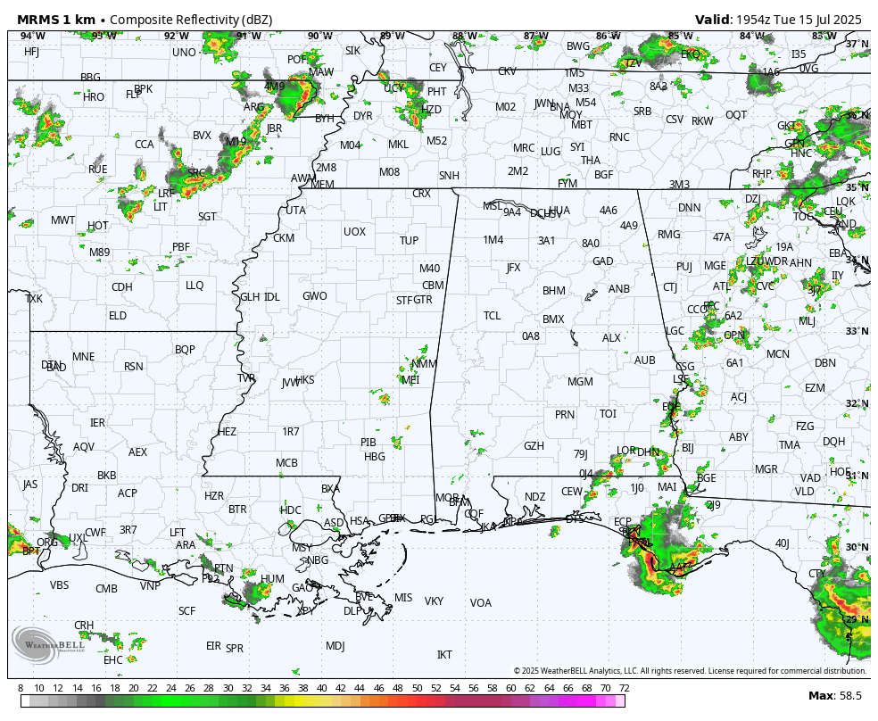
Alabama’s weather won’t change much tomorrow. Partly to mostly sunny, hot, and humid with just a few isolated afternoon showers and storms; highs will be in the mid 90s for most places.
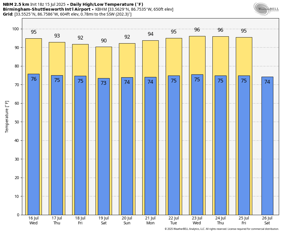
We expect a general increase in the number of scattered showers and thunderstorms Thursday through the weekend, with some of the highest coverage over the southern third of the state as a broad low/potential tropical depression moves through the northern Gulf. But, even there it won’t rain all day and the sun will be out at times. Most (but not all) of the showers and storms will come during the afternoon and evening hours, between 1:00 and 10:00 p.m. Heat levels will be a tad lower with highs in the 89-93 degree range.
And, for next week, the weather looks very routine for summer. Partly sunny days with the risk of a passing afternoon shower or thunderstorm in scattered spots. Highs rise back into the mid 90s… See the video briefing for maps, graphics, and more details.
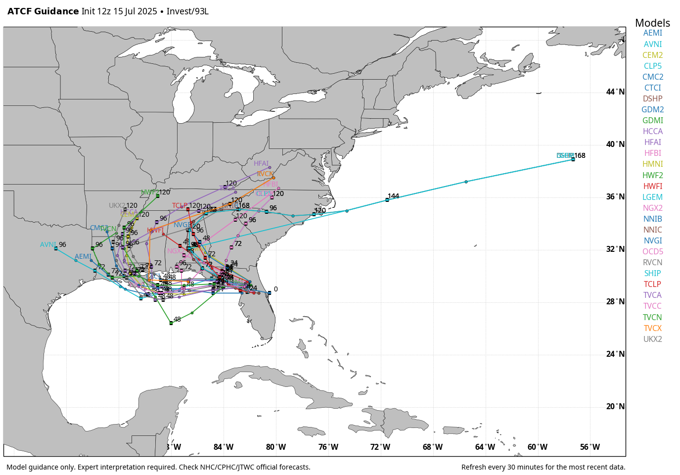
TROPICS: Satellite and radar data indicate that the low pressure area previously over the Atlantic is moving onto the coast of northeastern Florida. This system is currently producing disorganized shower and thunderstorm activity, and little development is expected through tonight while the center is over land.
Once the system reaches the northeastern Gulf tomorrow, environmental conditions appear generally favorable for additional development, and a tropical depression could form while the system moves across the northeastern and north-central Gulf and approaches the coast of Louisiana on Thursday. NHC gives it a 40 percent chance of development.
This will be mainly a rainmaker; models continue to show little development. It is very unlikely that this becomes a strong tropical storm or hurricane. For the central Gulf coast (Gulf Shores to Panama City Beach), elevated coverage of showers and thunderstorms is likely late tomorrow into Thursday, but the rain won’t be continuous, and the sun will be out at times on Thursday. Showers should thin out by Friday and the weekend as the broad low continues to move inland and away from the region.
The biggest concern is a high danger of rip currents on the coast Thursday and Friday.
ON THIS DATE IN 1901: The city of Marquette, Michigan set their all-time record high temperature with 108-degree reading.
ON THIS DATE IN 2003: Hurricane Claudette made landfall along the middle Texas coast near Port O’Connor at category one strength. Claudette was the first hurricane to strike the Port O’Connor and Matagorda Bay area since Hurricane Fern on September 10, 1971. Historical records dating back to 1851 indicate Claudette is the first July hurricane to make landfall in this area.
Look for the next video briefing here by 6:00 a.m. tomorrow…
Category: Alabama's Weather, ALL POSTS, Weather Xtreme Videos
About the Author (Author Profile)
James Spann is one of the most recognized and trusted television meteorologists in the industry. He holds the AMS CCM designation and television seals from the AMS and NWA. He is a past winner of the Broadcast Meteorologist of the Year from both professional organizations.Subscribe
If you enjoyed this article, subscribe to receive more just like it.


