Warm Today; Back In The Deep Freeze Over The Weekend
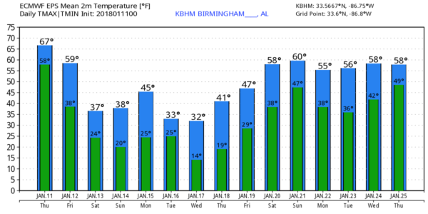
BIG CHANGES AHEAD: We project a high in the low 70s today, almost 20 degrees above average for January 11, and not far from the record high of 78, set in 1949. Quite the contrast to the weather on this date in 1982, when Birmingham dropped to -1F, one day before a crippling ice storm started.
Showers are possible today; rain becomes more widespread tonight and tomorrow morning as a cold front pushes through the state. Rain amounts of around 3/4″ are expected, and while some thunder is possible, there is no risk of severe storms.
WINTER WEATHER WOES TO THE NORTH TOMORROW: Rain will end from west to east during the midday hours, and as cold, Arctic air returns, a “wintry mix” of freezing rain, sleet, and snow is possible over the far northern part of Alabama.
*A winter weather advisory is in effect tomorrow for Lauderdale, Limestone, Madison, and Jackson counties (the counties that touch the Tennessee border).
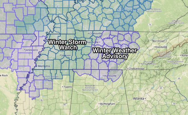
*Light ice/snow accumulation, under 1/2 inch, in these counties could bring about some bridge icing during the day. Higher accumulation totals will be to the north, over parts of Tennessee and Kentucky.
*Highest accumulation of ice/snow over Tennessee will be over the western half of the state; amounts over East Tennessee will be pretty light (places like Knoxville and Gatlinburg).
*While a patch of sleet or a snowflake or two is possible as far south as Birmingham tomorrow evening, no accumulation or impact is expected for Alabama south of the Tennessee River.
COLD WEEKEND: We will forecast a clearing sky Saturday, but the high will be only in the 37-40 degree range with a stuff north wind. We drop into the upper teens early Sunday, and then we expect sunshine in full supply during the day Sunday with a high in the upper 30s.
NEXT WEEK: A clipper passes north of the state Tuesday, and pulls down a reinforcing shot of Arctic air. Looks like highs will be in the mid to upper 30s Tuesday and Wednesday, and the GFS is printing a low of 14 for Birmingham early Wednesday morning. Then, look for a slow warming trend Thursday and Friday. Seems like the next chance of showers will come around Sunday January 21. See the Weather Xtreme video for maps, graphics, and more details.
BEACH FORECAST: Click here to see the AlabamaWx Beach Forecast Center page. The Beach Forecast is partially underwritten by the support of Brett/Robinson Vacation Rentals in Gulf Shores and Orange Beach. Click here to see Brett/Robinson’s Hot Deals now!
WEATHER BRAINS: Don’t forget you can listen to our weekly 90 minute netcast anytime on the web, or on iTunes. This is the show all about weather featuring many familiar voices, including our meteorologists here at ABC 33/40.
CONNECT: You can find me on all of the major social networks…
Facebook
Twitter
Google Plus
Instagram
Pinterest
Snapchat: spannwx
Look for the next Weather Xtreme video here by 4:00 this afternoon… enjoy the day!
Category: Alabama's Weather, ALL POSTS, Weather Xtreme Videos
About the Author (Author Profile)
James Spann is one of the most recognized and trusted television meteorologists in the industry. He holds the AMS CCM designation and television seals from the AMS and NWA. He is a past winner of the Broadcast Meteorologist of the Year from both professional organizations.Subscribe
If you enjoyed this article, subscribe to receive more just like it.


