Severe Storms Possible Across Alabama Tonight
ACTIVE WEATHER AHEAD: We note a few small showers on radar across Central Alabama this morning, but a decent part of the day today will be dry; the sky will be mostly cloudy. A south wind will increase this afternoon, and we project a high in the low 70s today, well above the average high of 56 for December 16.
SEVERE STORMS POSSIBLE: A dynamic weather system will bring the threat of strong to severe thunderstorms to Alabama late this afternoon and tonight. SPC has some western counties in an “enhanced risk” (level 3/5) of severe storms… the standard “slight risk” (level 2/5) is defined as far east as Huntsville, Gadsden, Alexander City, Troy, and Andalusia, and the rest of East Alabama is in a “marginal risk” (level 1/5).
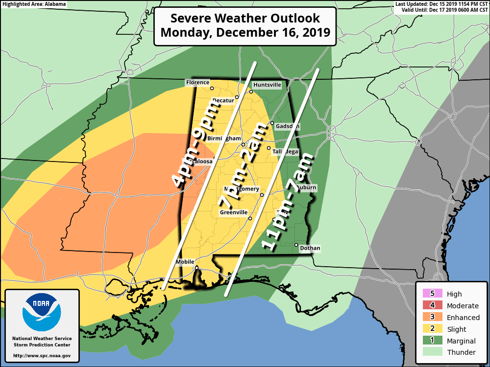
There will be sufficient instability and shear to support severe storms on a large scale; still some questions concerning how the mesoscale features play out tonight. But, certainly everyone in Alabama will need to pay attention to the weather and heed warnings if they are issued.
TIMING: A few severe storms are possible over far West and Northwest Alabama as early as 4:00, but the core threat comes tonight, after 6:00. Storms could linger across East and Southeast Alabama through 7:00 a.m. tomorrow.
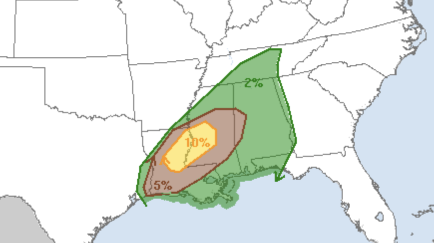
THREATS: Storms tonight will be capable of producing large hail, damaging winds, and a few tornadoes. For now SPC shows the higher tornado probabilities west of Alabama over parts of Mississippi and Louisiana.
RAIN: Rain amounts of 1-2 inches are likely for most of the state through tomorrow morning. No major flooding issues are expected.
CALL TO ACTION: Be sure you have a way of hearing severe weather warnings tonight if they are needed. Never a siren. Every Alabama home and business needs a NOAA Weather Radio, properly programmed with a fresh battery backup. Have WEA (Wireless Emergency Alerts) enabled on your phone, and download the free ABC 33/40 Weather app to get notifications as well (just search for it on the App Store). In your safe place, have helmets for everyone (including adults). And, if you live in a mobile home, you have to leave if you are in a tornado warning polygon; know where you are going, and the quickest way of getting there.
REST OF THE WEEK: Tomorrow will be mostly cloudy and sharply colder; temperatures over the northern half of the state hold in the 40s all day with a chilly northwest wind of 15-25 mph. Some lingering rain is possible tomorrow morning over the southeast counties. Wednesday and Thursday will be dry with a good supply of sunshine both days; morning lows will be in the 20s. The high Wednesday will be close to 50, followed by low 50s Thursday.
High clouds will move in Friday ahead of an upper air system, but the sky will be partly sunny with a high in the 50s. It looks like the air will be too dry for any meaningful chance of rain.
THE ALABAMA WEEKEND: The weekend will be dry and pleasant with mostly sunny conditions both days; the high Saturday will be in the low 60s, followed by mid 60s Sunday.
CHRISTMAS WEEK: An upper ridge will likely keep the weather dry and pleasant much of the week. Temperatures will be above average with highs in the 60s… if you are looking for a white Christmas, don’t look anywhere in Alabama. See the Weather Xtreme video for maps, graphics, and more details.
ON THIS DATE IN 2000: An EF-4 tornado tore through the southern part of Tuscaloosa, killing eleven people and injuring over 100. Nine of the fatalities occurred in mobile homes, one in a vehicle, and one in a commercial building converted to residential use. Six of those killed were females and five were males. Ages ranged from 16 months to 83 years old. The tornado was on the ground for a total of 18 miles, all within Tuscaloosa county. The tornado path was estimated to be 750 yards wide at it’s maximum intensity.
There was an excellent warning for the tornado; a warning was issued at 12:40 p.m. on that deadly Saturday, 14 minutes before the twister first touched down in a rural area southwest of Tuscaloosa near the Black Warrior River. The tornado crossed Alabama 69 near Shelton State Community College and Hillcrest High School; destroying a shopping center and many homes. The Bear Creek Trailer Park was hit, where many of the deaths occurred. The tornado moved to the east/northeast, south of Skyland Boulevard, and finally crossed I-59/20 near the Cottondale exit.
Later in the day, the same parent storm dropped an EF-3 tornado which stuck the Coats Bend region of Etowah County, near Gadsden, destroying 250 homes and injuring 14 people. Like the Tuscaloosa tornado, excellent warnings were issued by the National Weather Service long before the damage occurred. Just another reminder we can have some very violent weather this time of the year; the core of our late fall/early winter tornado season.
BEACH FORECAST: Click here to see the AlabamaWx Beach Forecast Center page.
WEATHER BRAINS: Don’t forget you can listen to our weekly 90 minute show anytime on your favorite podcast app. This is the show all about weather featuring many familiar voices, including our meteorologists here at ABC 33/40.
CONNECT: You can find me on all of the major social networks…
Facebook
Twitter
Instagram
Pinterest
Snapchat: spannwx
I have a weather program this morning at Mount Olive Elementary… look for the next Weather Xtreme video here by 4:00 this afternoon. Enjoy the day!
Category: Alabama's Weather, ALL POSTS, Weather Xtreme Videos
About the Author (Author Profile)
James Spann is one of the most recognized and trusted television meteorologists in the industry. He holds the AMS CCM designation and television seals from the AMS and NWA. He is a past winner of the Broadcast Meteorologist of the Year from both professional organizations.Subscribe
If you enjoyed this article, subscribe to receive more just like it.


