Flash Flood Watch Continues; Not As Wet As Yesterday
RADAR CHECK: A band of steady, light to moderate rain is on radar at daybreak from near Aliceville to Tuscaloosa to Birmingham to Anniston, otherwise the sky is cloudy with temperatures generally in the 60s. A flash flood warning has been issued for the southern half of Tuscaloosa County until 9:15 a.m. CT.
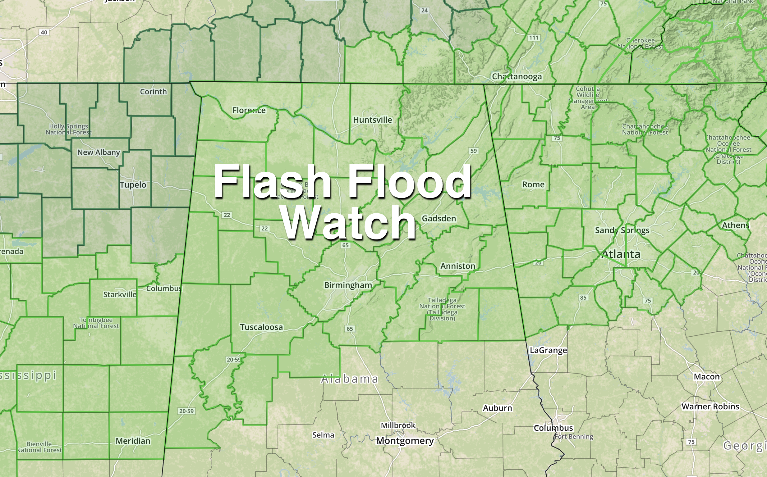
NWS offices in Huntsville and Birmingham continue a flash flood watch for roughly the northern half of the state today, but the good news is that the rain won’t be as heavy or as widespread as yesterday. Additional rain amounts over the next 24 hours should be around 1/2 to 1 inch. Of course, creeks, streams, and rivers remain swollen, and in some cases out of the their banks.
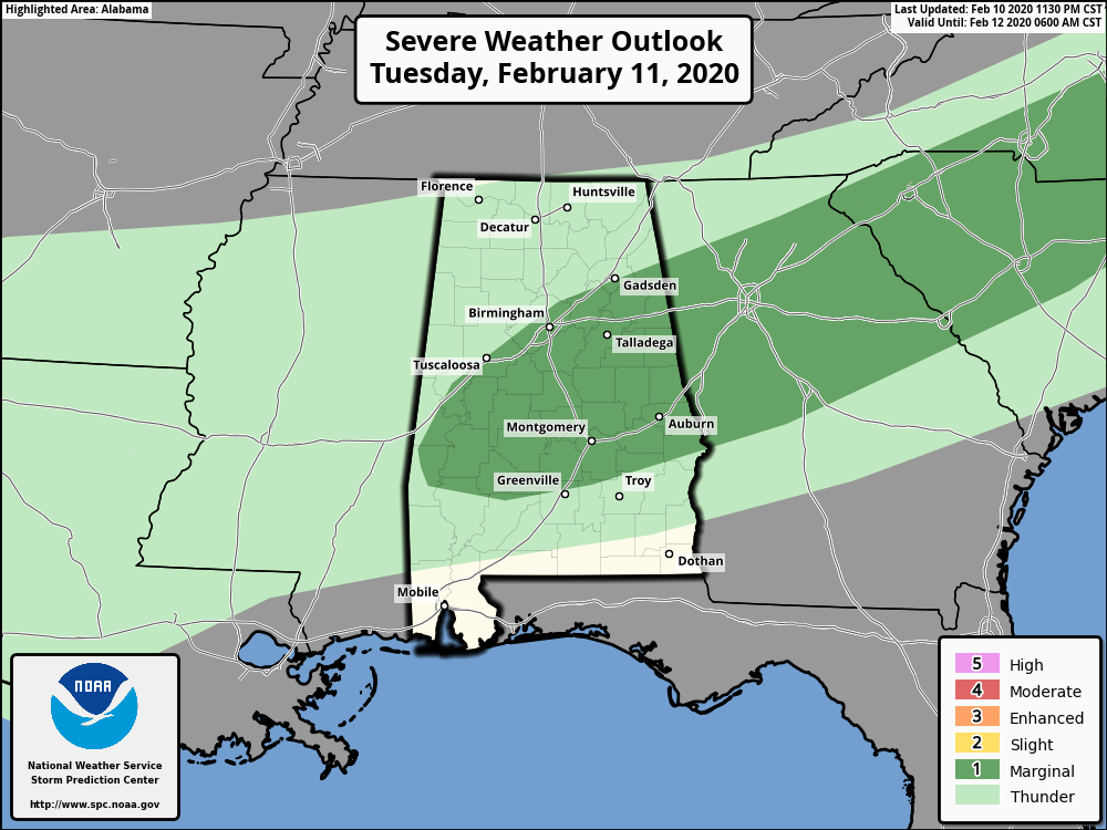
We do note SPC has defined a low end, “marginal risk” (level 1/5) of severe storms today for parts of Central Alabama… a few storms this afternoon could produce gusty winds or small hail, but the overall severe weather threat is low.
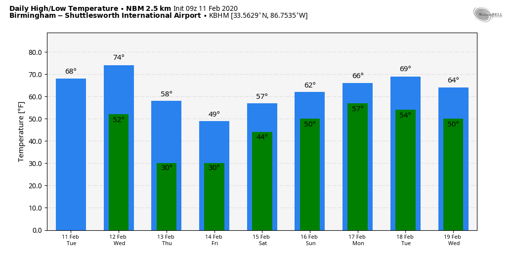
SEVERE STORMS POSSIBLE TOMORROW NIGHT: Tomorrow will be mild and breezy with a few showers possible, but a decent part of the day will be dry. Temperatures will rise into the low 70s by afternoon ahead of an approaching cold front.
That front will push a band of strong, possibly severe thunderstorms into Alabama tomorrow night. Models continue to suggest low surface based instability values over the state, which should limit the overall threat. SPC has removed the “enhanced risk”, but they maintain a “slight risk” (level 2/5) for much of the state tomorrow night into early Thursday morning.
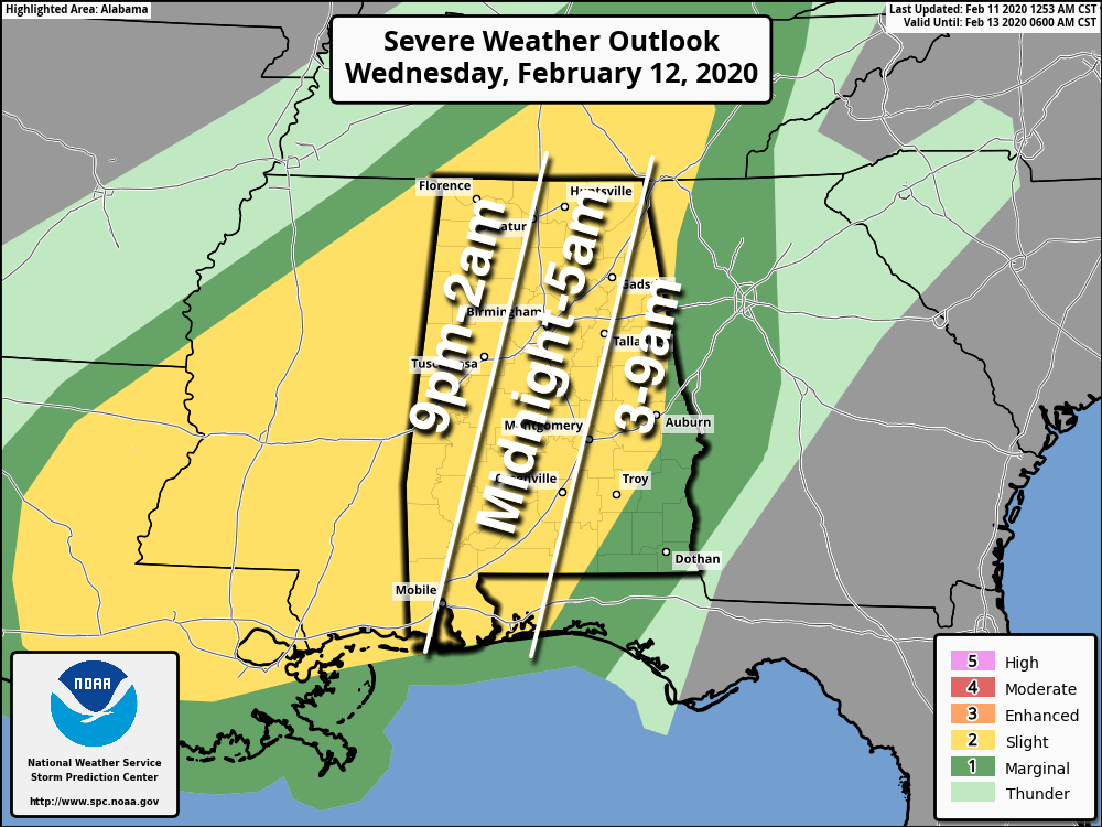
TIMING: The window for strong to severe storms will open up around 9:00 tomorrow night over West Alabama. Better chance of a few severe storms could very well hold off until after midnight for Birmingham and points east… and the threat will wind down early Thursday morning.
THREATS: Heavier storms tomorrow night could produce hail, damaging winds, and possible a brief tornado or two. For now the overall tornado threat looks fairly low, but certainly not zero.
RAIN: Rain amounts of 1/2 to 1 inch are likely tomorrow night, and with the ground totally saturated some flooding issues could develop overnight.
Rain and storms will end early in the day Thursday, and we could see some clearing late in the day with a high in the 50s.
FRIDAY AND THE WEEKEND: Friday will be sunny and cold. We start the day in the mid to upper 20s in many areas, and the high will be in the upper 40s. Sunny weather continues Saturday; once again we will deal with a sub-freezing start (most places will start the day in the 20s), followed by a high in the mid 50s. Clouds increase Sunday, and some rain could reach the state by late afternoon. The high Sunday will be in the low 60s.
NEXT WEEK: The pattern favors mild and generally unsettled weather; highs will be in the 60s and there will be some risk of rain daily, especially during the first half of the week. See the Weather Xtreme video for maps, graphics, and more details.
TOO MUCH RAIN: Here are some rain totals yesterday from the ABC 33/40 Skywatchers…
Woodstock 4.92″
Vestavia Hills 4.84″
Coker 4.40″
Bibbville 4.31″
Crestwood 4.13″
Bessemer 3.74″
Mountain Brook 3.14″
Jemison 3.12″
Grayson Valley 2.84″
Remlap 2.43″
Millport 2.07″
Rainbow City 1.77″
ON THIS DATE IN 1983: Called the “Megalopolitan blockbuster snowstorm,” this major snowstorm impacted the Mid-Atlantic and southern New England. Snowfall up to 25 inches fell at Allentown, Pennsylvania. Snowfall amount of 35 inches occurred in parts of the Blue Ridge Mountains of West Virginia at Glen Cary. Windsor Locks, Connecticut recorded a record 19 inches in 12 hours. A ship sunk off the Virginia/Maryland coast killing 33. There were 46 total storm-related fatalities.
BEACH FORECAST: Click here to see the AlabamaWx Beach Forecast Center page.
WEATHER BRAINS: Don’t forget you can listen to our weekly 90 minute show anytime on your favorite podcast app. This is the show all about weather featuring many familiar voices, including our meteorologists here at ABC 33/40.
CONNECT: You can find me on all of the major social networks…
Facebook
Twitter
Instagram
Pinterest
Snapchat: spannwx
I have weather programs today at Spring Garden School in Cherokee County, and Kitty Stone Elementary in Jacksonville…. look for the next Weather Xtreme video here by 4:00 this afternoon. Enjoy the day!
Category: Alabama's Weather, ALL POSTS, Weather Xtreme Videos
About the Author (Author Profile)
James Spann is one of the most recognized and trusted television meteorologists in the industry. He holds the AMS CCM designation and television seals from the AMS and NWA. He is a past winner of the Broadcast Meteorologist of the Year from both professional organizations.Subscribe
If you enjoyed this article, subscribe to receive more just like it.


