Warm, Humid Days With A Few Scattered Storms
RADAR CHECK: A batch of strong thunderstorms is moving across the Tennessee Valley region of North Alabama early this morning; these storms are producing frequent lightning and gusty winds, but are expected to remain below severe limits. They will move out of the state by mid-morning; otherwise, today will be warm and humid with a mix of sun and clouds, and some risk of scattered storms this afternoon and this evening. The high today will be in the mid-80s for most communities; the average high for May 22 at Birmingham is 83.
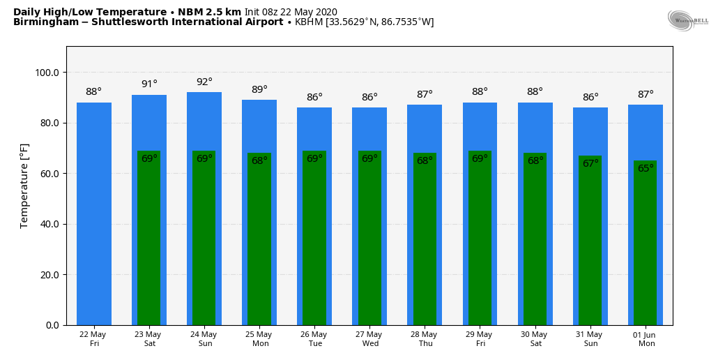
MEMORIAL DAY WEEKEND: We project highs in the 87-91 degree range tomorrow through Monday. The sky will be partly sunny, and we will deal with the typical risk of “scattered, mostly afternoon and evening showers and thunderstorms”. No way of knowing in advance exactly when and where they will form… if you have something planned outdoors you will just have to watch radar trends. The chance of any one spot getting wet each day will be in the 30/40 percent range; very routine weather for late May in Alabama.
NEXT WEEK: The upper ridge will hold over the region, and the weather just won’t change much. Day to day variations in the coverage and placement of scattered showers and storms will be determined by small scale features that the synoptic models just can’t handle days in advance, so we will roll with a persistence forecast. Highs will be mostly in the upper 80s. See the Weather Xtreme video for maps, graphics, and more details.
ON THIS DATE IN 2011: Less than one month after the generational tornado outbreak on April 27 that killed 252 people in Alabama, a supercell thunderstorm tracked from extreme southeast Kansas into far southwest Missouri that produced an EF-5 tornado over Joplin, Missouri causing incredible devastation and a tragic loss of life. This storm along with others generated additional tornadoes, wind damage, and flash flooding across far southwest Missouri.
A large portion of Joplin, Missouri was devastated by an EF-5 (greater than 200 mph) tornado resulting in 158 fatalities and over 1000 injured in the Joplin MO area. The Joplin tornado is the deadliest since modern record-keeping began in 1950 and is ranked 7th among the deadliest tornadoes in U.S. history.
BEACH FORECAST: Click here to see the AlabamaWx Beach Forecast Center page.
WEATHER BRAINS: Don’t forget you can listen to our weekly 90 minute show anytime on your favorite podcast app. This is the show all about weather featuring many familiar voices, including our meteorologists here at ABC 33/40.
CONNECT: You can find me on all of the major social networks…
Facebook
Twitter
Instagram
Pinterest
Snapchat: spannwx
We are on a holiday schedule, so just one video today, but I will post fresh forecast notes here by 4:00 this afternoon. Enjoy the day!
Category: Alabama's Weather, ALL POSTS, Weather Xtreme Videos
About the Author (Author Profile)
James Spann is one of the most recognized and trusted television meteorologists in the industry. He holds the AMS CCM designation and television seals from the AMS and NWA. He is a past winner of the Broadcast Meteorologist of the Year from both professional organizations.Subscribe
If you enjoyed this article, subscribe to receive more just like it.


