Scattered To Numerous Showers/Storms Later Today
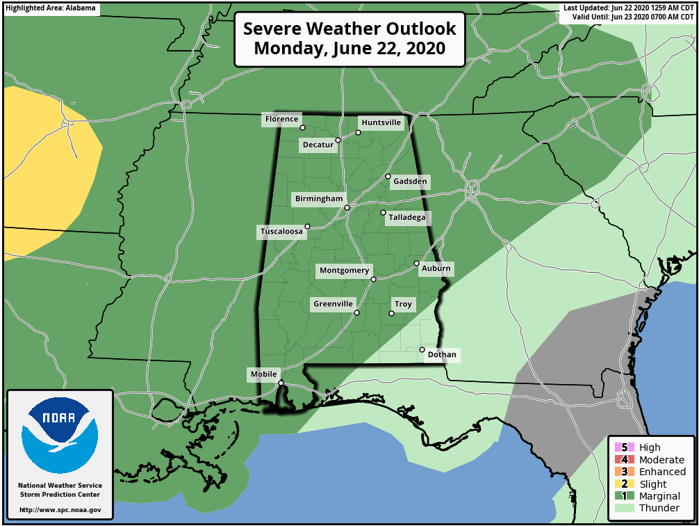
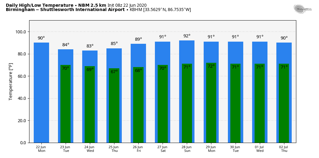
UNSETTLED PATTERN: Moist, unstable air now covers all of Alabama, and we expect scattered to numerous showers and thunderstorms to fire up later today and early tonight. The chance of any one spot getting wet today will be in the 70/80 percent range, and the high will be in the mid 80s for most communities. SPC has much of the state in a “marginal risk” (level 1/5) of severe thunderstorms; like yesterday heavier thunderstorms this afternoon could produce small hail and strong, gusty winds.
TALLADEGA: The Geico 500 was postponed yesterday due to two passing afternoon storms at the Talladega Superspeedway. The overall weather pattern won’t be any different today, but there is no skill in knowing the exact placement and intensity of the thunderstorms that develop this afternoon. The race is scheduled for 2:00p CT; certainly a chance they get the race in, but they will have to dodge the “pop up” showers and storms. Temperatures will be in the 80s.
REST OF THE WEEK: We will see scattered to numerous showers and thunderstorms tomorrow through Thursday, mostly during the afternoon and evening hours (generally from 1:00 until 9:00 p.m.) with highs in the low 80s. Showers should thin out a bit Friday as drier air creeps into the state; the high Friday will be in the mid 80s.
THE ALABAMA WEEKEND: For now it looks like we will experience fairly routine summer weather Saturday and Sunday. A mix of sun and clouds both days with “scattered, mostly afternoon and evening showers and thunderstorms”. Heat levels will rise a bit with afternoon highs around 90… odds of any one place seeing rain both days will be in the 40/50 percent range.
NEXT WEEK: We will roll with a persistence forecast through much of next week; partly sunny days and the risk of random, scattered showers and storms during the afternoon and evening hours. Highs around 90… classic late June weather in Alabama. See the Weather Xtreme video for maps, graphics, and more details.
TROPICS: Shower activity associated with a low pressure system located several hundred miles southeast of Cape Cod, Massachusetts is continuing to become less organized. The low has moved over cold water north of the Gulf Stream, and tropical or subtropical development has become less likely. The system is expected to weaken as it moves over even colder waters later today and Tuesday.
AFRICAN DUST: The SAL (Saharan Air Layer), with origins over the deserts of Africa, is pushing through the Caribbean this morning, and should reach parts of the southern U.S. later this week. This dry, dusty air is transported in high levels of the atmosphere, generally between 5,000 and 20,000 feet, and the main effect is creating very vivid sky scenes at sunrise and sunset due to the scattering of sunlight. The dry air also mitigates any tropical storm formation. There can be a reduction in air quality, but most of the dust is several thousand feet off the ground and is not an issue for most people. And, this is NOT unusual in summer.
ON THIS DATE IN 2007: The first officially documented F5 tornado in Canada struck the town of Elie, Manitoba population 500 people. Video of the storm showed a heavy van being whirled through the air. The storm also tossed an almost entire house several hundred yards through the air before it disintegrated. The tornado traveled across the landscape for about 35 minutes covering 3.4 miles and leaving a damage path 984 feet wide. Wind speeds in the tornado were later estimated at 260-316 mph. Fortunately, no fatalities or serious injuries were reported.
BEACH FORECAST: Click here to see the AlabamaWx Beach Forecast Center page.
WEATHER BRAINS: Don’t forget you can listen to our weekly 90 minute show anytime on your favorite podcast app. This is the show all about weather featuring many familiar voices, including our meteorologists here at ABC 33/40.
CONNECT: You can find me on all of the major social networks…
Facebook
Twitter
Instagram
Pinterest
Snapchat: spannwx
Look for the next Weather Xtreme video here by 4:00 this afternoon… enjoy the day!
Category: Alabama's Weather, ALL POSTS, Weather Xtreme Videos
About the Author (Author Profile)
James Spann is one of the most recognized and trusted television meteorologists in the industry. He holds the AMS CCM designation and television seals from the AMS and NWA. He is a past winner of the Broadcast Meteorologist of the Year from both professional organizations.Subscribe
If you enjoyed this article, subscribe to receive more just like it.


