Very Typical August Weather This Week
JUST WHAT YOU EXPECT IN SUMMER: A flat upper ridge covers the Deep South, and will remain in place through the week. This keeps the main mid-latitude westerly winds aloft (the jet stream) well to the north, and will set the stage for very routine August weather. We are forecasting partly sunny days with the daily round of random, scattered, mostly afternoon and evening showers and thunderstorms. Most of the showers will come from 1:00 until 11:00 p.m., and the odds of any one spot getting wet reach day are in the 35-45 percent range.
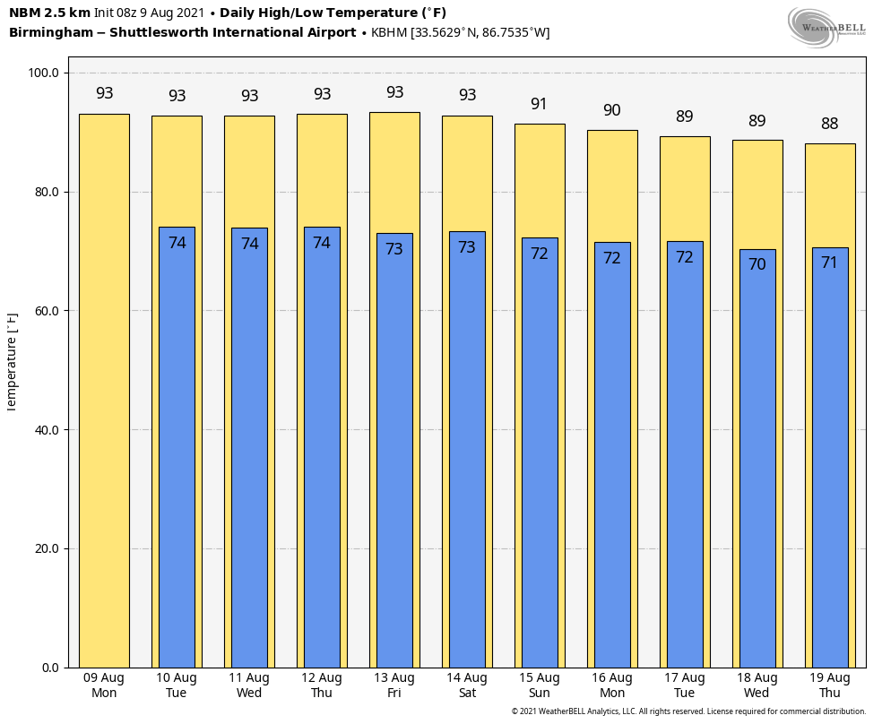
Some locations will see a soaker, but just down the road it will be dry. And, no way of knowing in advance exactly when and where they form… if you have something planned outdoors you just have to watch radar trends. Afternoon highs will be generally in the low 90s, right at average values for mid-August in Alabama.
THE ALABAMA WEEKEND: I don’t see any reason for the weather to change. Partly sunny, hot, humid with scattered showers and storms during the afternoon and evening hours. The high both days will be close to 90, and odds of your front yard seeing rain both days remain at 35-45 percent.
NEXT WEEK: There is some evidence we could see a little increase in the number of scattered showers and storms early in the week due to an upper low nearby, but otherwise the routine summer weather will likely continue, but with lower heat levels. Highs will drop into the 87-90 degree range most days. See the Weather Xtreme video for maps, graphics, and more details.
TROPICS: We are watching two tropical waves in the Atlantic. One is a low pressure area located about 1000 miles east of the Lesser Antilles. Development of this system is becoming less likely during the next few days while it moves toward the west or west-southwest at around 10 mph.
The one to watch is Invest 94L, which is about 380 miles east-southeast of the Leeward Islands. It is producing disorganized showers and thunderstorms. Environmental conditions are expected to be conducive for some development over the next few days, and a tropical depression could form while the low moves west-northwestward at about 15 mph. The disturbance is forecast to reach portions of the Lesser Antilles by late tonight, then move near the Virgin Islands and Puerto Rico tomorrow, and be near Hispaniola around the middle of this week. Tropical storm watches or warnings could be required with
shorter-than-normal lead times for portions of the Leeward Islands, the Virgin Islands, and Puerto Rico. In addition, heavy rains and flooding are likely for the Leeward Islands, Virgin Islands, and Puerto Rico.
Models take 94L right over Hispaniola and Cuba later this week, and if this happens interaction with these islands could result in the system dissipating, or weakening greatly. If anything survives, it could wind up in the far Southeast Gulf of Mexico this weekend, but that is a big “IF”.
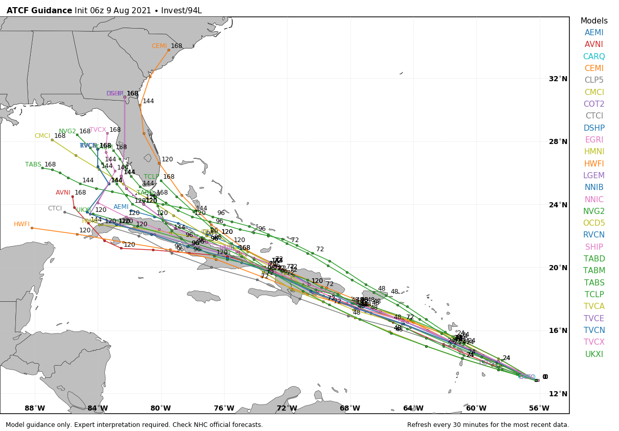
The rest of the Atlantic basin, including the Gulf of Mexico, is quiet.
ON THIS DATE IN 1969: An F3 tornado hit Cincinnati, Ohio, killing four persons and causing fifteen million dollars property damage. The tornado moved in a southeasterly direction at 40 to 50 mph.
BEACH FORECAST: Click here to see the AlabamaWx Beach Forecast Center page.
WEATHER BRAINS: Don’t forget you can listen to our weekly 90 minute show anytime on your favorite podcast app. This is the show all about weather featuring many familiar voices, including our meteorologists here at ABC 33/40.
CONNECT: You can find me on all of the major social networks…
Look for the next Weather Xtreme video here by 3:00 this afternoon… enjoy the day!
Category: Alabama's Weather, ALL POSTS, Weather Xtreme Videos
About the Author (Author Profile)
James Spann is one of the most recognized and trusted television meteorologists in the industry. He holds the AMS CCM designation and television seals from the AMS and NWA. He is a past winner of the Broadcast Meteorologist of the Year from both professional organizations.Subscribe
If you enjoyed this article, subscribe to receive more just like it.


