Routine Summer Weather For Alabama; Eyes On The Tropics
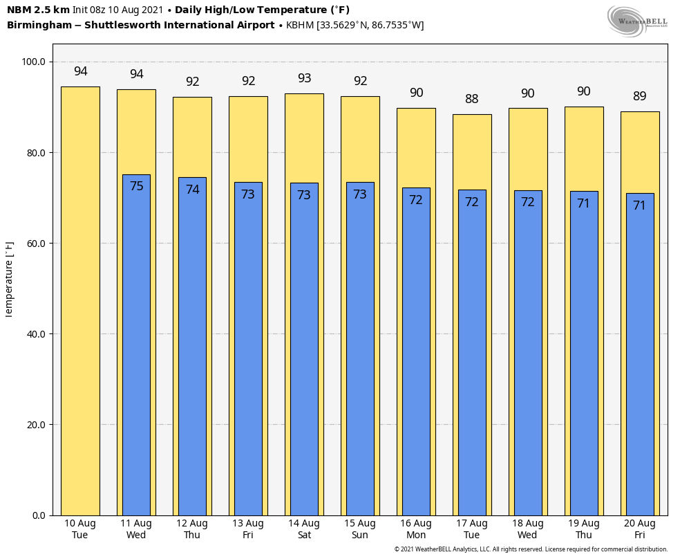
ROUTINE AUGUST WEATHER: Alabama’s weather won’t change much for the rest of the week. Look for partly sunny, hot, humid days with random, scattered showers and thunderstorms around each day, mostly between 1:00 and 10:00 p.m. The chance of any one neighborhood seeing rain each afternoon will be in the 30-40 percent range, and afternoon highs will be in the 90-93 degree range. Just what you expect in mid-August.
THE ALABAMA WEEKEND: No real change; mixed sun and clouds Saturday and Sunday with the risk of a passing afternoon shower or thunderstorm both days. Highs will be pretty close to 90 degrees.
NEXT WEEK: The weather early in the week will be determined by a tropical system potentially moving inland from the eastern Gulf of Mexico. At the moment, it looks like Alabama could be on the drier, west side of the circulation, but there is no way of resolving details now. Otherwise, we will stick with a persistence forecast through the week with typical summer weather… highs will be in the 87-90 degree range most days. See the Weather Xtreme video for maps, graphics, and more details.
PTC 6: Potential Tropical Cyclone 6, now in the far eastern Caribbean, is expected to become Tropical Storm Fred later today or tonight. Tropical storm conditions are expected in portions of the U.S. Virgin Islands and Puerto Rico beginning this afternoon, and in the Dominican Republic tomorrow. Tropical storm conditions are possible in northern Haiti and the southeastern Bahamas by tomorrow night.
Intensification potential will be limited by interaction with the mountainous island of Hispaniola, dry air in the mid levels, and westerly shear. If the system survives, the NHC forecast has it as a tropical storm in the eastern Gulf of Mexico southwest of Tampa Bay Saturday night. It is important to remember that average track errors at days 4 and 5 with NHC forecasts are 175 miles and 200 miles, respectively.
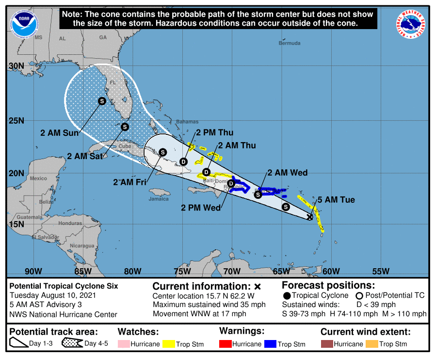
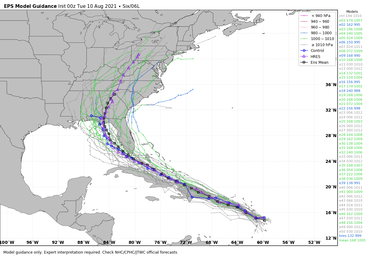
From there, long range modeling suggests there could be a potential landfall over the eastern Florida panhandle in six days (Monday of next week). But this system has not even developed a core, and there is no way of knowing now the ultimate destination or intensity. If you have a beach trip planned next week, I would not cancel or make any changes; just keep an eye on the system.
The rest of the Atlantic basin is quiet.
ON THIS DATE IN 1856: A hurricane destroyed Isle Dernieres or Last Island, a pleasure resort south-southwest of New Orleans on this day. The highest points of the island were under five feet of water. The resort hotel was destroyed, along with the island’s gambling establishments. Over 200 people perished, and the island lost all its vegetation and split in half. Only one cow remained on the island after the catastrophe. The Last Island is now just a haven for pelicans and other seabirds.
BEACH FORECAST: Click here to see the AlabamaWx Beach Forecast Center page.
WEATHER BRAINS: Don’t forget you can listen to our weekly 90 minute show anytime on your favorite podcast app. This is the show all about weather featuring many familiar voices, including our meteorologists here at ABC 33/40.
CONNECT: You can find me on all of the major social networks…
Look for the next Weather Xtreme video here by 3:00 this afternoon….
Category: Alabama's Weather, ALL POSTS, Weather Xtreme Videos
About the Author (Author Profile)
James Spann is one of the most recognized and trusted television meteorologists in the industry. He holds the AMS CCM designation and television seals from the AMS and NWA. He is a past winner of the Broadcast Meteorologist of the Year from both professional organizations.Subscribe
If you enjoyed this article, subscribe to receive more just like it.


