Winter Storm Warning For North Alabama; Severe Storms Possible Tonight For South Alabama
WILD WEATHER PATTERN: The weather across Alabama will be about as active as it gets over the next 24 hours; we will have a significant snow event for the northern counties after midnight tonight, while strong to severe thunderstorms are possible across the southern half of the state.
Most of the day today will be dry with a high in the 70s; a few scattered showers could show up this afternoon. The main action comes tonight.
SEVERE STORM POTENTIAL: SPC maintains a “slight risk” (level 2/5) of severe thunderstorms for areas south of a line from Millry to Prattville to Roanoke tonight, with a “marginal risk” (level 1/5) as far north as Demopolis, Brent, Helena, and Jacksonville.
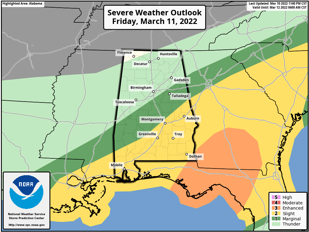
The main window for strong to severe storms tonight will come from 7:00 p.m. until 3:00 a.m. The main threat will come from strong straight line winds, but a few tornadoes are possible as well… the higher tornado potential will be in the “slight risk” area across South and Southeast Alabama. Be sure you have a way of hearing severe weather warnings tonight if they are needed!
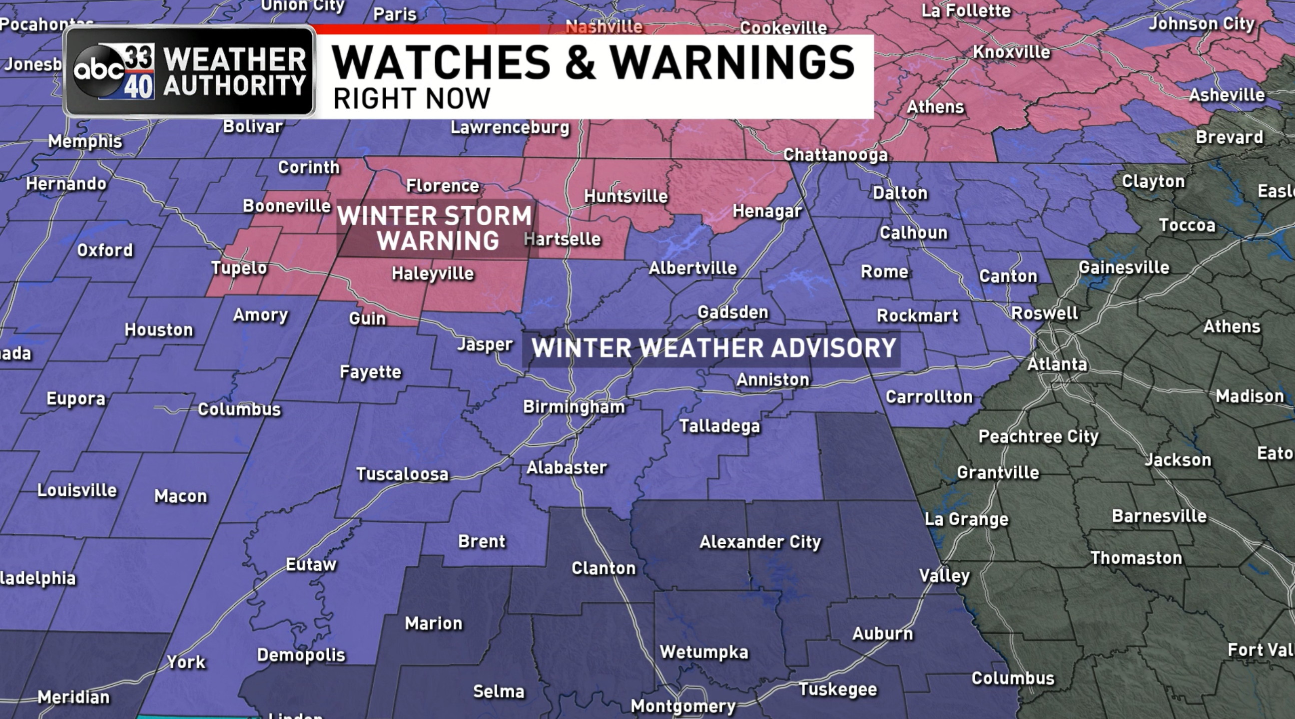
SNOW: A winter storm warning has been issued for Marion, Winston, Franklin, Colbert, Lauderdale, Lawrence, Limestone, Morgan, Madison, and Jackson counties tonight, and a winter weather advisory is in effect as far south as Livingston, Brent, Sylacauga, and Heflin.
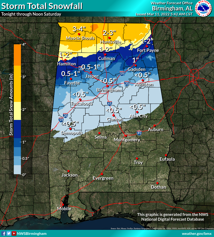
Snow amounts of 2-4 inches are now forecast in the winter storm warning area, with totals generally in the 1/2 to 1 inch range across the winter weather advisory area.
The rain will change to snow over North Alabama late tonight; most of the snow will fall from midnight to 6:00 a.m. Roads and bridges will likely become icy and dangerous across the winter storm warning area; slick spots will form on bridges across the winter weather advisory area (including Tuscaloosa/Birmingham/Anniston/Gadsden).
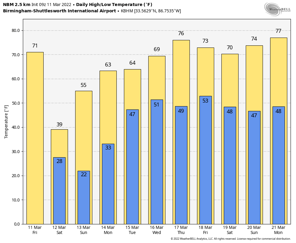
The sky will be sunny most of the day tomorrow, but temperatures will hold in the 30s over the northern counties of the state, and the wind chill index will hover around freezing all day thanks to an icy north wind.
Temperatures early Sunday morning will drop into the 16-24 degree range for the northern half of Alabama… many places will be below freezing for 8-12 hours. A freeze likely all the way down to the Gulf Coast… this will be a very significant late season freeze. Then, during the day Sunday, the sky will be sunny with a high in the 50s as a warming trend begins.
NEXT WEEK: Monday will be dry with a high in the 60s; showers return to the state Tuesday into part of the day Wednesday as an upper trough moves through. Thursday will be dry and mild with a high in the 70s, followed by showers and possibly a few strong storms Friday. See the Weather Xtreme video for maps, graphics, and more details.
ON THIS DATE IN 1888: The Great Blizzard of 1888 paralyzed the east coast from the Chesapeake Bay to Maine on March 11 through the 14th. The blizzard dumped as much as 55 inches of snow in some areas, and snowdrifts of 30 to 40 feet were reported. An estimated 400 people died from this blizzard.
BEACH FORECAST: Click here to see the AlabamaWx Beach Forecast Center page.
WEATHER BRAINS: Don’t forget you can listen to our weekly 90 minute show anytime on your favorite podcast app. This is the show all about weather featuring many familiar voices, including our meteorologists here at ABC 33/40.
CONNECT: You can find me on all of the major social networks…
Look for the next Weather Xtreme video here by 3:00 this afternoon… enjoy the day!
Category: Alabama's Weather, ALL POSTS, Weather Xtreme Videos
About the Author (Author Profile)
James Spann is one of the most recognized and trusted television meteorologists in the industry. He holds the AMS CCM designation and television seals from the AMS and NWA. He is a past winner of the Broadcast Meteorologist of the Year from both professional organizations.Subscribe
If you enjoyed this article, subscribe to receive more just like it.


