Wind/Rain/Storms For Alabama Tonight
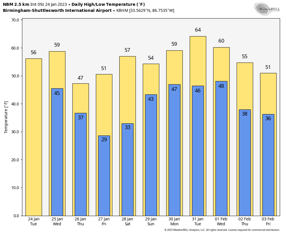
HIGH IMPACT WEATHER TONIGHT: Alabama’s weather will stay dry today with a partly sunny sky… expect highs in the 50s over the northern counties this afternoon, with 60s to the south. Clouds will increase late in the day.
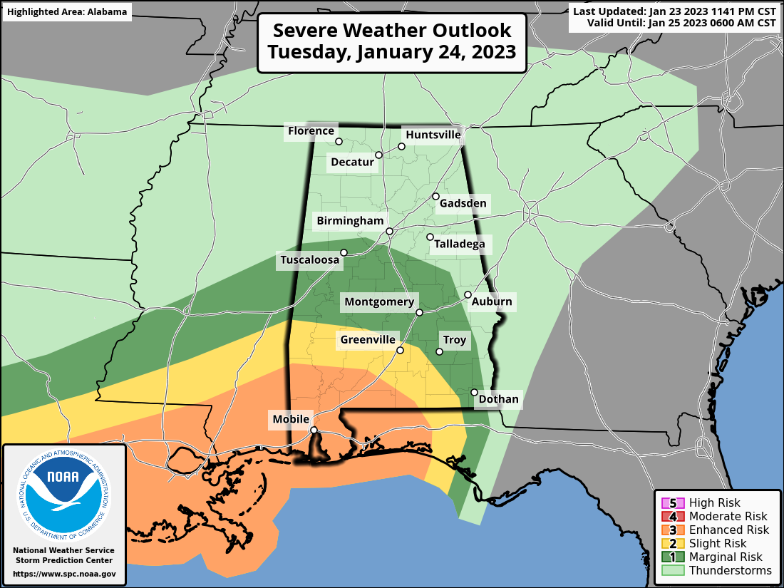
A dynamic weather system will bring wind, rain, and thunderstorms to the state tonight. SPC maintains an enhanced risk (level 3/5) of severe storms tonight for areas south of a line from Millry to Evergreen to Brewton. A “slight risk” (level 2/5) extends as far north and east as Sweetwater, Greenville, and Geneva. A “marginal risk” is defined as far north as Tuscaloosa, but severe thunderstorms are not expected over North/Central Alabama with no surface based instability available.
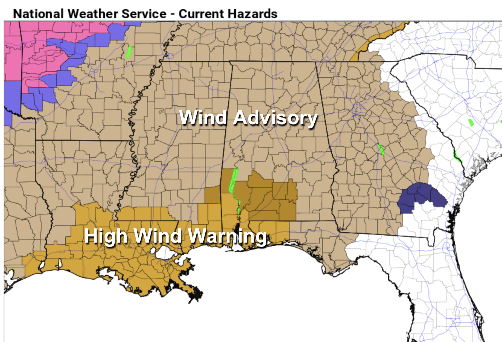
GRADIENT WIND: It is important to note that while the core threat of severe thunderstorms is confined to the southwest corner of Alabama, the entire state will see strong gradient winds (not related to thunderstorms) tonight. A wind advisory is in effect statewide, and a high wind warning has been issued for Mobile, Baldwin, and Washington counties. Expect wind gusts tonight to 40 mph at times, which could bring down some trees due to the wet soil conditions. Those along ridges could see a gust to 50 mph spots. It will be very windy and noisy tonight.
SEVERE THUNDERSTORMS: Thunderstorms across Southwest Alabama in the “enhanced risk” area could produce hail, damaging winds, and a few tornadoes tonight. A strong tornado (EF-2 or higher) can’t be ruled out. The air over the northern half of the state will be cool and stable, and very little thunder is expected there (gradient winds are the concern).
TIMING: High gradient winds are likely over the state from about 8:00 tonight through mid-morning tomorrow. Gusts are still possible to 25/30 mph tomorrow afternoon before diminishing tomorrow night. In terms of severe thunderstorms across Southwest Alabama, the window comes from 11:00 tonight through 4:00 a.m. tomorrow.
For those of you in Southwest Alabama, be sure and have a reliable way of hearing warnings late tonight and during the pre-dawn hours tomorrow morning. NEVER rely on a siren! A NOAA Weather Radio is the baseline, and be sure and have Wireless Emergency Alerts (WEA) enabled on your phone. If you live in a mobile home, know the location of the nearest shelter, or business that is open 24/7 that can serve as a safe place. And have transportation available.
Everyone statewide should secure loose objects on your property due to the expected strong wind gusts tonight.
The rain will end tomorrow morning… clouds will linger through the afternoon with temperatures in the 50s.
THURSDAY/FRIDAY: Thursday will be colder with a mix of sun and clouds; highs will be in the 40s over North Alabama, with 50s for the southern counties. A few light snow flurries can’t be ruled out Thursday morning over the Tennessee Valley, but no accumulation or impact is expected. Friday will feature a good supply of sunshine with highs in the 50s and 60s.
THE ALABAMA WEEKEND: Saturday will be dry with a partly to mostly sunny sky; highs will remain in the 50s and 60s. Clouds return Saturday night, and occasional rain is likely Sunday with highs in the 50s. The air will be stable Sunday so no severe storms are expected.
NEXT WEEK: A decent part of the day Monday will be dry, but expect periods of rain Tuesday through Thursday. Much colder air arrives by the end of the week; too early to know how cold, and if there will be any chance of wintry mischief as the cold air arrives. See the daily Weather Briefing video for maps, graphics, and more details.
ON THIS DATE IN 1967: A tornado outbreak across the Central U.S. was the furthest north ever recorded in the winter up to that time. Severe weather occurred across a good portion of the southeast and east-central Iowa. Two-inch hail fell at Armstrong, and over two dozen tornadoes were reported. Five miles north of Fort Madison, one fatality occurred from a tornado, along with six injuries. A tornado causing F4 damage killed 3 people and injured 216 in St. Louis County, Missouri. Storms also affected parts of northern and central Illinois. One strong tornado in Mason County killed one person and injured three others.
BEACH FORECAST: Click here to see the AlabamaWx Beach Forecast Center page.
Look for the next Weather Briefing video here by 3:00 this afternoon… enjoy the day!
Category: Alabama's Weather, ALL POSTS, Weather Xtreme Videos
About the Author (Author Profile)
James Spann is one of the most recognized and trusted television meteorologists in the industry. He holds the AMS CCM designation and television seals from the AMS and NWA. He is a past winner of the Broadcast Meteorologist of the Year from both professional organizations.Subscribe
If you enjoyed this article, subscribe to receive more just like it.


