Clearing, Breezy, Sharply Colder Today
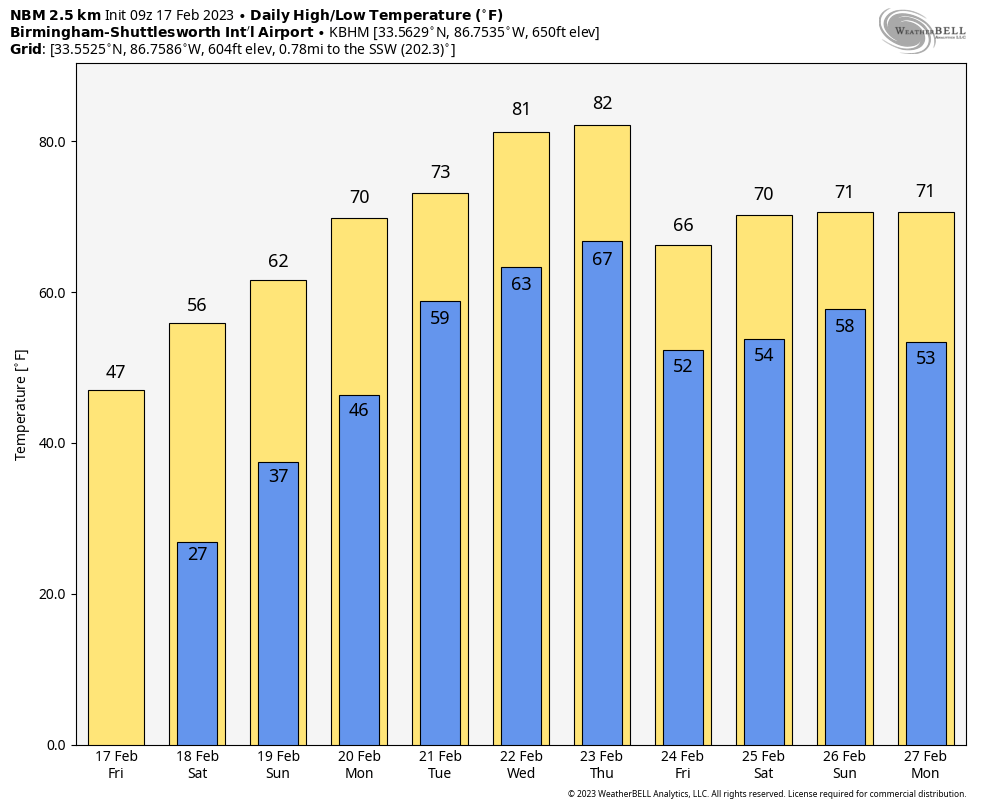
RADAR CHECK: Rain continues just before daybreak in areas east and south of Birmingham… that rain will be ending soon, and we expect clearing from northwest to southeast this morning. Most communities will be under a sunny sky this afternoon, but the day will be breezy and sharply colder with highs in the 40s over the northern third of the state. Temperatures across South Alabama will settle into the 50s. Tonight will feature a clear sky with temperatures falling into the 20s in most places.
The weekend will feature sunny days, clear nights, and a warming trend. Expect highs in the 50s tomorrow, followed by 60s Sunday.
NEXT WEEK: It looks like the warmest week so far this year, with potential for highs exceeding 80 degrees by Wednesday and Thursday. In terms of rain chances, forecast confidence is very low with model inconsistency and differences. We will mention a chance of showers Tuesday, and a few thunderstorms are possible Wednesday. Way too early to know if severe storms will be an issue; forecast will be better in coming days. See the daily Weather Briefing video for maps, graphics, and more details.
ENHANCED RISK BUST: SPC and all of us in the weather enterprise took a beating over the “enhanced risk” bust yesterday as severe storms were a no-show, but it isn’t the first time, and won’t be the last. Predicting the future is hard; ask those who fill out March Madness brackets next month.
But, being wrong with a severe weather forecast isn’t taken lightly. False alarms lead to the “cry wolf” syndrome, and nobody will pay attention. We have to get better.
Initial observations…
*The air aloft was a little too warm today; we are too close to the strong upper ridge just southeast of Alabama. Meaning, instability values were not nearly as high as models forecast this afternoon.
*The upper trough to the northwest kept a positive tilt, and played less of a role in diffluence aloft and upward atmospheric motion.
*Stronger winds aloft and dynamic forcing were a little too far north to play a big role here today. Storm relative helicity values just weren’t very impressive.
*Long time viewers and readers know my saying… “All models are wrong, some are useful”. Mesoscale models didn’t perform very well today.
We did our best to communicate that days like this happen often during our tornado season, which runs from November through May. The was much anxiety concerning this event forecast for today in recent days for some reason, possibly related to the fact that SPC forecast a severe weather threat for Alabama today seven days in advance.
But let’s all be thankful we didn’t have property damage, injuries, and loss of life today. Indeed, we “got through the day together just fine”.
ON THIS DATE IN 2008: An EF-3 tornado tore through Prattville and Millbrook, injuring over 50 people. The tornado was down for 14 miles; An estimated 200 residential homes and 40 businesses were damaged or destroyed. Eleven other tornadoes touched down across Central and South Alabama that day.
ON THIS DATE IN 2022: Three tornadoes touched down in Alabama, including an EF-1 that moved from near Lake Purdy to just south and east of Leeds.
BEACH FORECAST: Click here to see the AlabamaWx Beach Forecast Center page.
Look for the next video briefing here by 3:00 this afternoon… enjoy the day!
Category: Alabama's Weather, ALL POSTS, Weather Xtreme Videos
About the Author (Author Profile)
James Spann is one of the most recognized and trusted television meteorologists in the industry. He holds the AMS CCM designation and television seals from the AMS and NWA. He is a past winner of the Broadcast Meteorologist of the Year from both professional organizations.Subscribe
If you enjoyed this article, subscribe to receive more just like it.


