Hot, Humid Days; A Few Storms For North Alabama
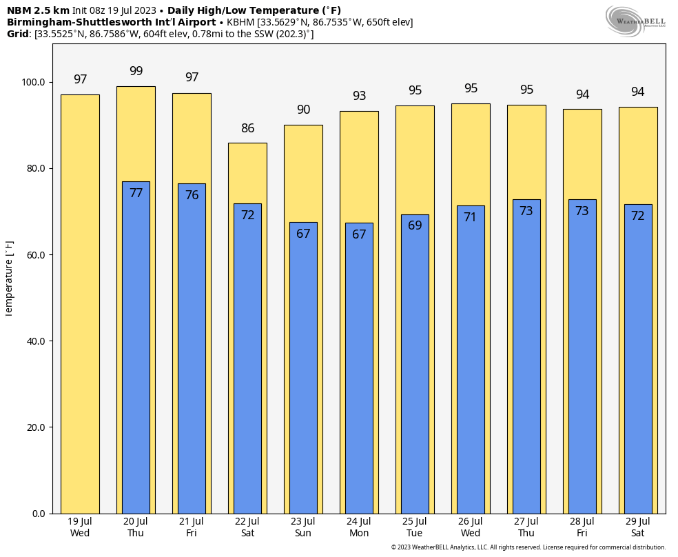
HOT, HUMID SUMMER WEATHER: We are getting exactly what we expect in the middle of July in Alabama through Friday… hot, humid days with highs in the 90s. A “heat advisory” has been issued for parts of the state today (mainly some of the central and southwest counties) where the heat index could touch 105.
Another part of the summer formula is scattered thunderstorms. Just before sunrise we have an organized mass of storms over Tennessee, and these will likely move into North Alabama by mid-morning. Like yesterday, the storms will be capable of producing strong winds, and the far northern part of the state is in a “marginal risk” (level 1/5) today.
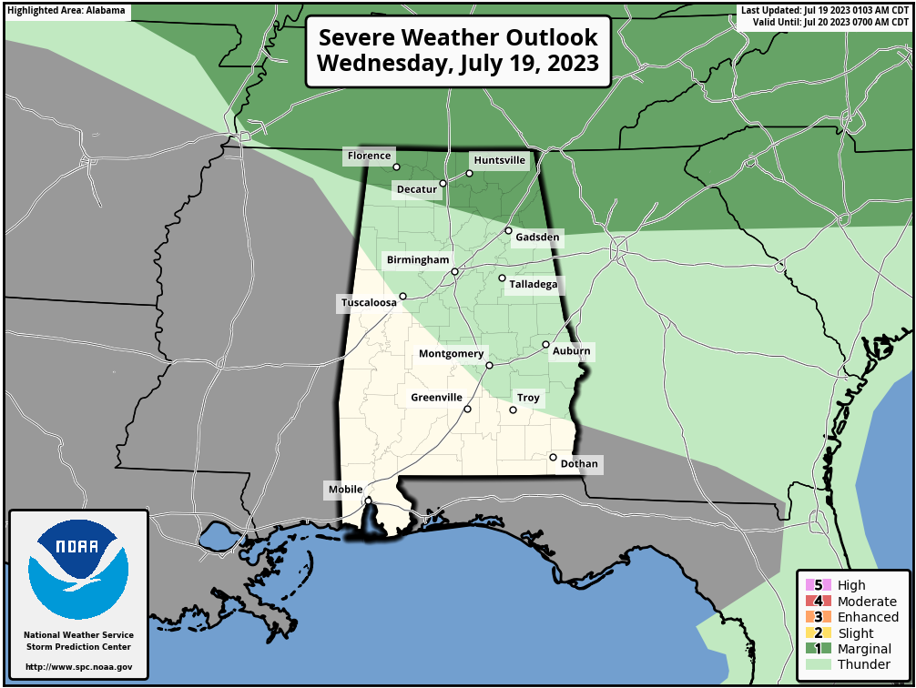
The storms are expected to fade and dissipate by afternoon, and a decent part of the state will be dry with a partly sunny sky. Mostly dry weather will continue tomorrow and during the day Friday with only isolated storms. A surface front will bring a band of thunderstorms into Alabama Friday night.
THE ALABAMA WEEKEND: Showers and storms will remain possible Saturday as the front sags southward… they will be most numerous over the southern 2/3 of the state. This won’t be an “all day” rain, and the sun will be out at times. Heat levels come way down as most places will see a high between 84 and 89 degrees. Then, on Sunday, the northern half of the state will be in a drier airmass. The sky will be mostly sunny with lower humidity levels… the high will be near 90 degrees. Scattered storms will remain possible Sunday across the southern counties.
NEXT WEEK: For now the week looks quiet with mostly sunny days, only isolated afternoon storms, and highs in the low to mid 90s. See the video briefing for maps, graphics, and more details.
TROPICS: Tropical Storm Don, a weak system with winds of only 40 mph, remains far from land and will likely dissipate by early next week in the cooler waters of the North Atlantic. The rest of the Atlantic basin, including the Gulf of Mexico, remains very quiet.
ON THIS DATE IN 1997: Hurricane Danny made landfall near Mullet Point as a Category 1 storm. Due to the slow motion of the system, it brought historic rain totals to Southwest Alabama. Radar estimated an incredible 43 inches of storm total rain over the open water in Mobile Bay. Observing sites reported 30-40 inches across the area with Dauphin Island reporting 36.71 inches with 25.98 inches of this falling between 5pm and midnight on July 19.
Record flooding caused major damage to homes along the Fowl River in Mobile County and the Fish River in Baldwin County. In Mobile County, most roads on Dauphin Island were covered with more than a foot of water. A CSX railroad trestle was undermined by flooding and collapsed at US 90 and Ramsey Road. In Baldwin County, numerous roads south of US 98 and near the Fish River were inundated and impassable for days. It was estimated that 80% of the Alabama public oyster reefs in Mobile County and 60% of the reefs in Baldwin County were destroyed.
ON THIS DATE IN 2006: A derecho impacted a sellout crowd of almost 44,000 St. Louis Cardinals fans, packed into the new Busch Stadium. Winds of about 80 mph whirled around the St. Louis area, sending the fans running for shelter. The winds knocked out power and broke windows out of the press box. Nearly two minutes after the winds began at 100 mph, they stopped, and it started to rain. In all, about 30 people were injured at the stadium.
Look for the next video briefing here by 3:00 this afternoon… enjoy the day!
Category: Alabama's Weather, ALL POSTS, Weather Xtreme Videos
About the Author (Author Profile)
James Spann is one of the most recognized and trusted television meteorologists in the industry. He holds the AMS CCM designation and television seals from the AMS and NWA. He is a past winner of the Broadcast Meteorologist of the Year from both professional organizations.Subscribe
If you enjoyed this article, subscribe to receive more just like it.


