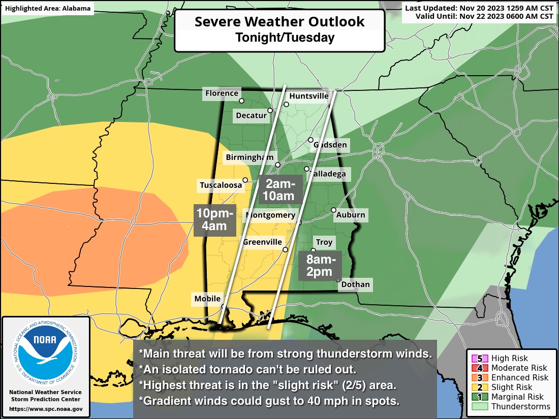
Strong/Severe Storms Possible Tonight/Early Tomorrow
ACTIVE WEATHER AHEAD: We have a few spotty showers on radar early this morning across Alabama; the air is cool and stable with temperatures in the 40s and 50s at daybreak. The sky will be generally cloudy today with a high at or over 70 degrees in many locations this afternoon. Tonight an organized batch of rain and thunderstorms will roll into the state tonight ahead of a dynamic storm system.
It is a fairly typical November setup; very good dynamics, but weak thermodynamics. The lack of surface based instability will limit the overall threat, but still the potential is there for strong, possibly severe thunderstorms.
SPC has defined a “slight risk” (level 2/5) for areas south and west of a line from Vernon to Northport to Montgomery to Greenville and Andalusia. Much of the rest of the state, with the exception of the northeast counties, is in a “marginal risk” (level 1/5).
Here are the key messages for the event…
*The main threat will come from strong thunderstorm winds, but an isolated tornado or two can’t be ruled out. Highest risk of a tornado is in the “slight risk” area across parts of West and South Alabama.
*The window for strong to severe thunderstorms will begin across far West Alabama around 10:00 p.m., with the risk progressing eastward during the night and into tomorrow morning. Storms should move out of the southeast corner of the state by early afternoon.
*Gradient winds (not related to thunderstorms) could gust to 40 mph in spots tonight; a wind advisory is in effect for the northern half of Alabama.
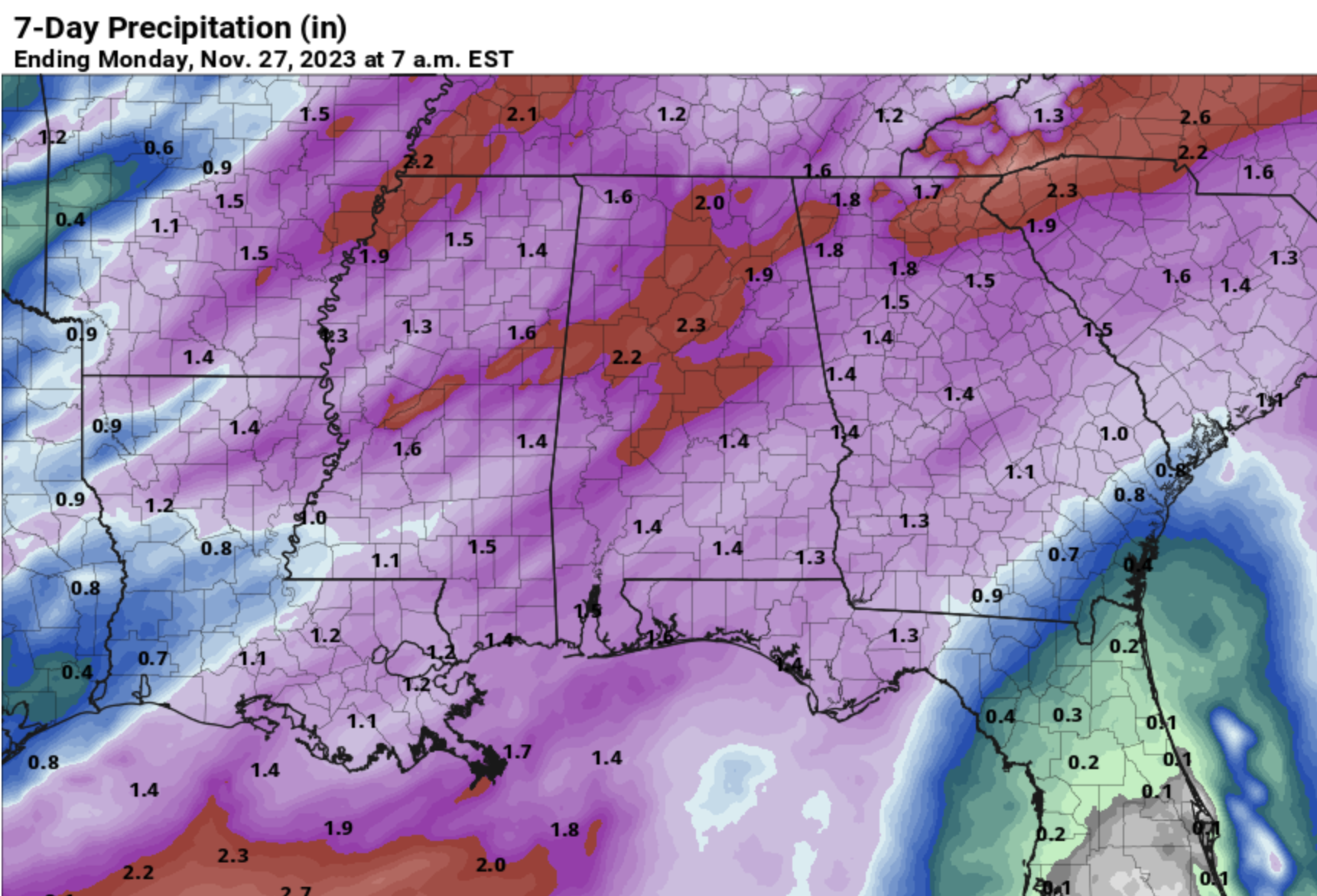
*On the positive side, beneficial rain is likely, with amounts of 1-2 inches expected statewide.
As severe weather events go in Alabama, this isn’t a “major” threat, but you have to always be ready and have a plan. Since most of the storms for the northern 2/3 of the state will come during the middle of the night, be sure you have a good way of hearing severe weather warnings in the event they are needed. The baseline is a NOAA Weather Radio, every home and business needs one! Be sure emergency alerts are enabled on your phone. Know the safe place in your home, and have helmets there for everyone in the family. If you live in a mobile home, know the location of the nearest shelter and how to get there quickly.
TOMORROW/WEDNESDAY: We might see a few peeks of sun tomorrow, but the day will be generally cloudy with highs in the 60s. As mentioned earlier, storms will move out of the southeast corner of the state by early afternoon. Then, a deep upper low will swing through North Alabama Wednesday… it will be a mostly cloudy and colder day with highs in the 48-54 degree range over the northern half of the state, with upper 50s and low 60s for the southern counties. A few sprinkles are possible under the upper low over the northern third of the state.
THANKSGIVING: Thanksgiving Day/Thursday looks cool and dry with a partly sunny sky. We start the day in the upper 30s and low 40s… the high will be in the 50s for most of the state. Clouds will increase Thursday night as a potential weak surface low forms in the northern Gulf of Mexico, but models have backed off a bit with this feature in recent runs. Some scattered light rain can’t be ruled out Thursday night.
FRIDAY AND THE WEEKEND: Any light rain from the Gulf feature will end early Friday; the rest of the day and the weekend will stay cool and dry with highs generally in the 50s, along with lows in the 30s and 40s. See the video briefing for maps, graphics, and more details.
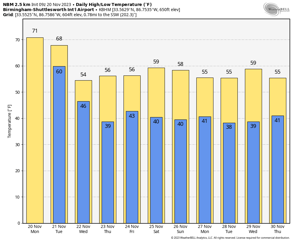
IRON BOWL FORECAST: We are expecting cool, dry weather for the biggest football game of the year Saturday (Alabama at Auburn; 2:30p CT kickoff). The sky will be partly sunny with a kickoff temperature near 60 degrees, falling into the 50s by the fourth quarter.
TROPICS: NHC is monitoring two disturbances, one in the Caribbean, one in the central Atlantic, but both have only a low chance of development at this point. The hurricane season ends at the end of the month.
ON THIS DATE IN 1900: A tornado outbreak in the Lower Mississippi Valley resulted in 73 deaths and extensive damage across Arkansas, Mississippi, and Tennessee.
ON THIS DATE IN 1985: Kate intensified to a major Category 3 Hurricane and as she moved west of Key West, Florida with top winds of 115 mph and a minimum central pressure of 954 millibars or 28.17 inches of mercury. The next day Kate made landfall between Panama City and Apalachicola, Florida. Tides ran 8 to 10 feet above normal. Many power poles and lines were downed. Several roads were washed out.
Look for the next video briefing here by 3:00 this afternoon… enjoy the day!
Category: Alabama's Weather, ALL POSTS, Weather Xtreme Videos
About the Author (Author Profile)
James Spann is one of the most recognized and trusted television meteorologists in the industry. He holds the AMS CCM designation and television seals from the AMS and NWA. He is a past winner of the Broadcast Meteorologist of the Year from both professional organizations.Subscribe
If you enjoyed this article, subscribe to receive more just like it.


