Midday Nowcast: More Rain and Storms
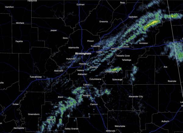
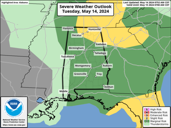
MORE RAIN AND STORMS: The weather remains unsettled with some scattered showers currently and a better chance of showers and storms this afternoon and evening. Where the storms form they could be strong with the potential for some small hail and gusty winds. A “marginal risk” (level 1/5) covers most of Alabama, while Northeast Alabama is included in a “slight risk” (level 2/5). The tornado threat is low, but not zero, especially over northeastern sections of the state. Temperatures are in the upper 70s and lower 80s across Alabama.
BIRMINGHAM ALMANAC: For May 14th, the average high for Birmingham is 82° and the average low is 61°. The record high is 93° set in 2018, while the record low is 41° set in 1971. We average 0.16” of precipitation on this date, and the record value is 2.58” set in 1976.
A COUPLE OF DRY DAYS: Drier air moves into Alabama tomorrow and continues into Thursday. Both these days will be mainly dry with only a few isolated showers over the Tennessee Valley. Highs these two days will range from the low to mid 80s with more sun than clouds.
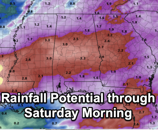
FRIDAY AND THE WEEKEND: Rain returns to Alabama Friday as a surface low approaches; the rain could be heavy at times through Friday night, but with the low passing to the south of us, any risk of severe storms will be confined to areas close to the Gulf Coast. Rainfall potential through Saturday morning will be in the 2-3 inch range for most of Alabama.
The weather looks to improve through the weekend with a clearing sky in Saturday. Sunday should feature sunshine in full supply. Highs will range from the low to upper 80s across Alabama.
NEXT WEEK: An upper ridge will build over the region, and for now a decent part of next week looks dry with highs in the mid to upper 80s. I would not be surprised to see more and more 90s starting to show up on the maps next week as well.
BEACH FORECAST CENTER: Get the latest weather and rip current forecasts for the beaches from Fort Morgan to Panama City on our Beach Forecast Center page. There, you can select the forecast of the region that you are interested in visiting.
WORLD TEMPERATURE EXTREMES: Over the last 24 hours, the highest observation outside the U.S. was 117.9F at Matam, Senegal. The lowest observation was -91.7F at Concordia, Antarctica.
CONTIGUOUS TEMPERATURE EXTREMES: Over the last 24 hours, the highest observation was 107F at Death Valley, CA. The lowest observation was 22F at Covington, MI.
Category: Alabama's Weather, ALL POSTS
About the Author (Author Profile)
Macon, Georgia Television Chief Meteorologist, Birmingham native, and long time Contributor on AlabamaWX. Stormchaser. I did not choose Weather, it chose Me. College Football Fanatic. @Ryan_StinnetSubscribe
If you enjoyed this article, subscribe to receive more just like it.


