Heat Levels Come Down A Bit This Weekend; Dry Pattern Continues
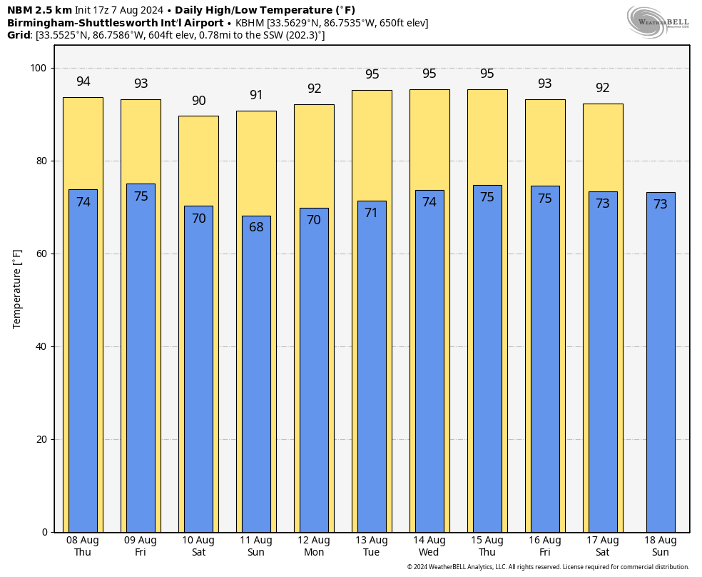
HOT SUMMER DAY: Temperatures are in the 90s across Alabama this afternoon with a partly to mostly sunny sky. A few tiny, isolated showers have formed, but most of the state is dry. Tonight will be fair with a low in the 70s.
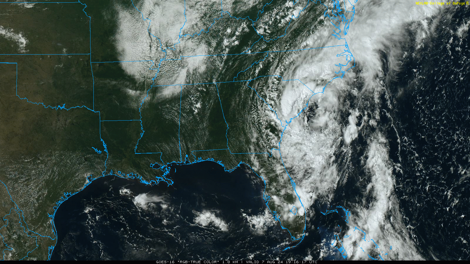
The chance of any one spot seeing a shower across Alabama stays at ten percent or less through the weekend, and when odds are that low we don’t mention it in the forecast. Look for mostly sunny days and fair nights through Sunday as the dry pattern continues, and Tropical Storm Debby stays well to the east.
We expect mostly mid 90s tomorrow and Friday, but a pattern change will bring down a drier, continental airmass over the weekend. For Saturday and Sunday, highs over the northern half of the state will drop into the 88-92 degree range with lower humidity and cooler nights. Temperatures will be in the 60s early Sunday morning for a little touch of fall.
NEXT WEEK: Generally dry weather will continue Monday and Tuesday. We will mention the chance of widely scattered, mostly afternoon and evening showers and thunderstorms over the latter half of the week, but we still don’t expect any really widespread rain. Highs will be in the low to mid 90s through most of the week… See the video briefing for maps, graphics, and more details.
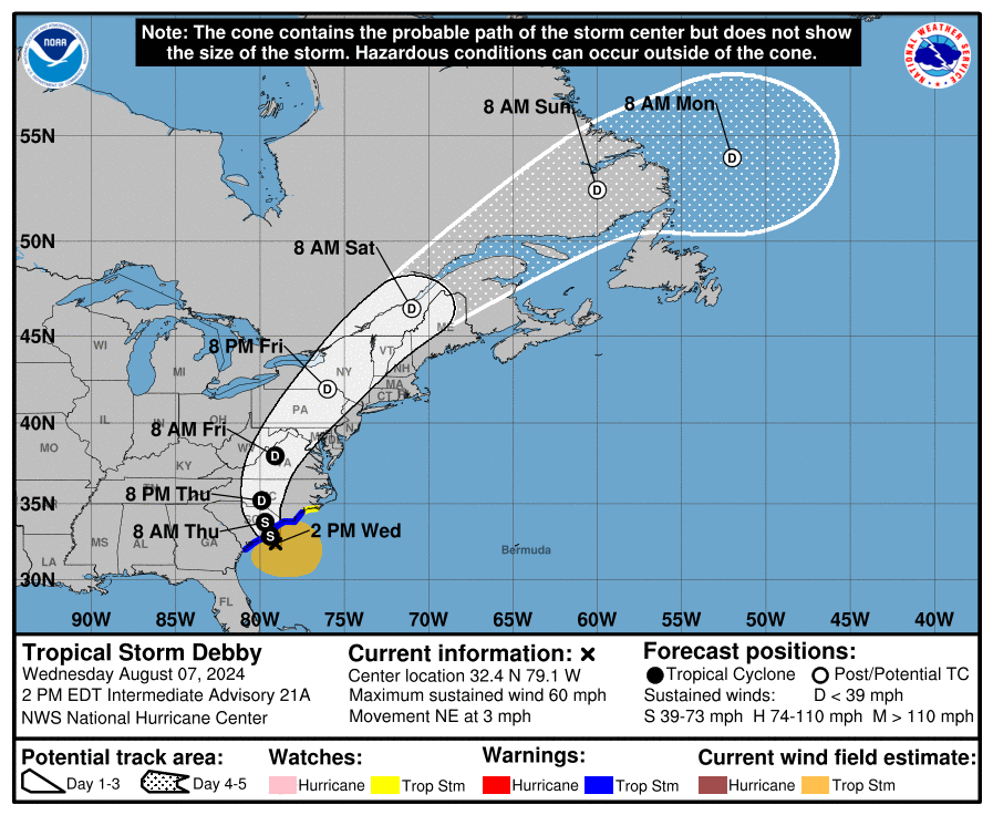
TROPICS: Tropical Storm Debby this afternoon is about 55 miles east/southeast of Charleston, and is drifting to the northeast at only 3 mph. The system will drift back inland tomorrow, and it finally begins to accelerate to the northeast Friday. By the Sunday it will be over eastern Canada.
Elsewhere, a tropical wave located over the southwestern Caribbean Sea is producing some disorganized showers and thunderstorms. The wave is forecast to move westward and inland over Central America during the next day or two, and development of this system is not expected. NHC has dropped the chance of development to 0 percent. The rest of the Atlantic basin is very quiet.
ON THIS DATE IN 1980: Hurricane Allen bottomed out at 899 millibars (26.55 inches of mercury) while moving through the Yucatan Channel in the southeastern part of the Gulf of Mexico. Allen was the second lowest pressure ever recorded in the Western Hemisphere up to that time. Allen’s winds at the time were sustained at 190 mph. It would move into South Texas on August 10, 1980 as a category three hurricane.
Look for the next video briefing here by 6:00 a.m. tomorrow…
Category: Alabama's Weather, ALL POSTS, Weather Xtreme Videos
About the Author (Author Profile)
James Spann is one of the most recognized and trusted television meteorologists in the industry. He holds the AMS CCM designation and television seals from the AMS and NWA. He is a past winner of the Broadcast Meteorologist of the Year from both professional organizations.Subscribe
If you enjoyed this article, subscribe to receive more just like it.


