Dry Today/Tomorrow; Some Rain Saturday Night/Sunday
COLD: Temperatures are generally in the 25-32 degree range over the northern half of Alabama early this morning, with mid 30s down into the southern counties. Expect sunshine in full force today with a high in the low to mid 50s this afternoon. We note the average high for Birmingham on December 12 is 58.
Tomorrow will be another sunny day with a high in the mid to upper 50s.
THE ALABAMA WEEKEND: The day Saturday will be dry with a high between 58 and 63 degrees. Clouds will increase by afternoon, and a few periods of rain are likely over the northern half of the state Saturday night. Then, Sunday looks dry for much of Alabama, although showers will remain possible for the Tennessee Valley. Sunday will feature a high in the low to mid 60s.
NEXT WEEK: Monday should be the warmest day of the week with highs in the mid to upper 60s. We will have a risk of showers Monday night, and then again during the day Thursday. Highs will be in the low to mid 60s Tuesday and Wednesday, followed by upper 50s Thursday, and low 50s Friday. See the video briefing for maps, graphics, and more details.
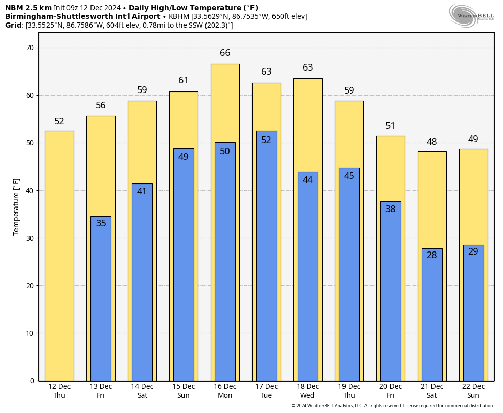
CHRISTMAS: No skill in a specific forecast beyond ten days, but there is some skill at pattern recognition. For now it looks like we will experience temperatures near average for late December, with highs in the 50s and lows in the 30s on December 25. Of course, this could change. Too early to know if there will be any threat of rain, but we are very confident in saying we won’t have any snow this year (which is the case almost every year around here).
ON THIS DATE IN 1962: A mass of very cold, Arctic air settled into the Deep South. Birmingham’s low the morning of December 12, 1962 was 4 degrees, which still stands as the record low for the date. Huntsville dropped to 3 degrees that morning. Montgomery’s low was 9.
Look for the next video briefing here by 3:00 this afternoon… enjoy the day!
Category: Alabama's Weather, ALL POSTS, Weather Xtreme Videos
About the Author (Author Profile)
James Spann is one of the most recognized and trusted television meteorologists in the industry. He holds the AMS CCM designation and television seals from the AMS and NWA. He is a past winner of the Broadcast Meteorologist of the Year from both professional organizations.Subscribe
If you enjoyed this article, subscribe to receive more just like it.


