Dry Today; Some Rain Tomorrow Night
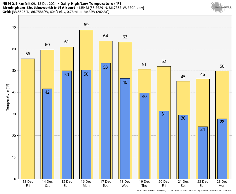
ANOTHER COLD START: Temperatures are below freezing across much of North Alabama this morning, with mid to upper 30s over the southern counties of the state. Expect a good supply of sunshine today with a high in the 55-61 degree range.
THE ALABAMA WEEKEND: Clouds will increase during the day tomorrow; temperatures will rise into the low 60s by afternoon. Then, a front will bring some light rain to mainly the northern of the state tomorrow night. Then, on Sunday, a decent part of the state will be dry, although a few showers are still possible across the Tennessee Valley. The high Sunday will be in the 60-65 degree range. Rain amounts over the weekend will be light, generally under 1/2 inch. Most South Alabama communities will be dry.
NEXT WEEK: We will have a chance of showers Monday night and Tuesday, followed by a more meaningful rain event Wednesday afternoon, Wednesday night, and Thursday morning. Highs will be close to 70 Monday, and in the 60s Tuesday and Wednesday. Cooler air returns Thursday and Friday with highs in the 50s.
Long range model data suggests highs will drop into the 40s the weekend before Christmas, with morning lows down in the 20s by December 22/23. A few model runs have hinted at snow flurries for parts of North Alabama around Saturday December 21 as the cold air arrives, but there is no evidence of anything meaningful for now. See the video briefing for maps, graphics, and more details.
ON THIS DATE IN 1997: A freak cold snap and snowstorm struck parts of northern Mexico, leaving 12 people dead and the area paralyzed. It snowed in the city of Guadalajara for the first time since 1881, leaving amazed residents to gawk at the white stuff and make snowmen. The temperature plunged to 5 degrees in Chihuahua.
Look for the next video briefing here by 3:00 this afternoon… enjoy the day!
Category: Alabama's Weather, ALL POSTS, Weather Xtreme Videos
About the Author (Author Profile)
James Spann is one of the most recognized and trusted television meteorologists in the industry. He holds the AMS CCM designation and television seals from the AMS and NWA. He is a past winner of the Broadcast Meteorologist of the Year from both professional organizations.Subscribe
If you enjoyed this article, subscribe to receive more just like it.


