Midday Nowcast: More Active Weather Pattern through Saturday; Some Strong Storms Expected

Click image to enlarge.
NEW MONTH, NEW WEATHER PATTERN: Welcome to May and the new month is starting off more active as rain and storms have returned to Alabama and the forecast. We are seeing a mostly cloudy sky, and showers and storms will increase in coverage through the afternoon and tonight.
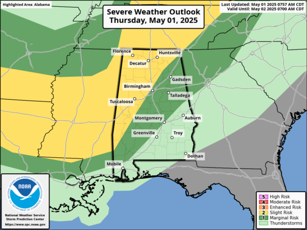
The Storm Prediction Center has a large portion of Alabama in a level 2 of threat of severe weather, while southeast of this risk is level 1 of 5 risk. With very limited dynamics and weak wind fields, the overall threat is low, but a few of the stronger storms could produce gusty winds and some hail. There is not a tornado threat with today’s storms. Highs today are in the low to mid 80s.
BIRMINGHAM ALMANAC: For May 1st, the average high for Birmingham is 79° and the average low is 57°. The record high is 92° set in 1901, while the record low is 38° set in 1908. We average 0.16” of precipitation on this date and the record value is 1.59” set in 1985.
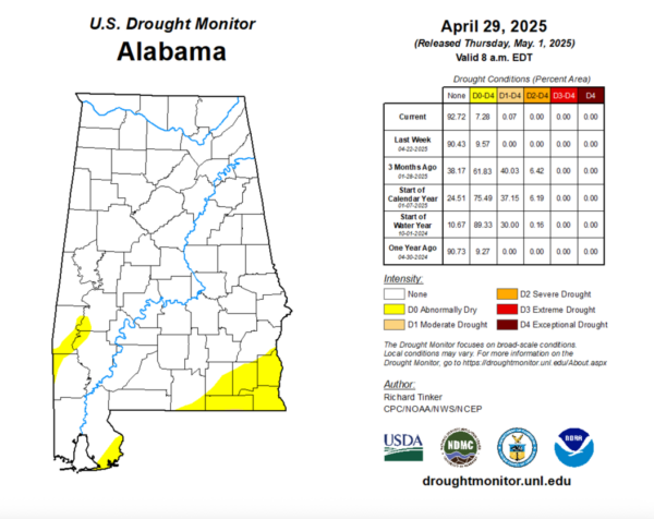
DROUGHT MONITOR: It is Thursday, meaning the latest drought monitor has been released. Some slight changes in drought conditions in Alabama. Abnormally Dry conditions have decreased to 7.28% of state, down from 9.57% last week. This includes areas of Southwest Alabama including portions of Choctaw, Washington, Clarke, and Marengo Counties. In Southeast Alabama, the Wiregrass Region, portions of Covington, Geneva, Coffee, Dale, Henry, and Houston counties are experiencing the conditions also southeastern portions of Baldwin County. Almost not worth mentioning, but moderate drought has been introduced to 0.07% of the state. Where you may say, extreme southern Geneva County along the Florida state line.
Click image to enlarge.
USA BRIEF: A low pressure center tracking across the Great Lakes and its associated cold front extending across the Southern Plains will focus occasional showers and thunderstorms through tonight. A few of these thunderstorms may become severe alongside heavy rainfall that may cause flash flooding; Portions of the Southern Plains would be the greatest threat for these hazards through tonight.
TOMORROW AND SATURDAY: Expect periods of rain and some storms both tomorrow and Saturday as a cold front slowly approaches and drifts southward. Again, there is a low end threat of severe storms, as stronger storms again will be capable of producing hail and gusty winds.
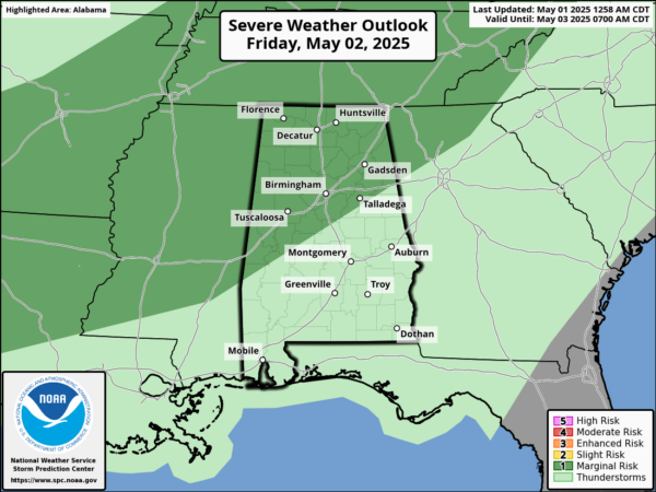
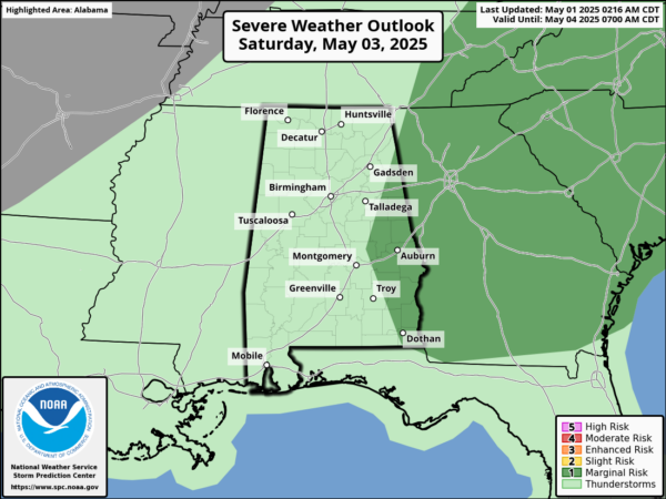
If you have an outdoor event planned on these days, understand it won’t rain all day. Just have the umbrella close and be ready for rain at times. Highs tomorrow will be in the low 80s; but Saturday will be much cooler with low and mid 70s. The threat for stronger storms Saturday will be shifting east of Alabama. Rain amounts through Saturday night will be in the 1-2 inch range for most of the state.
SPLENDID SUNDAY: The front pushes south and drier air surges south into the state. The sky becomes mostly sunny and after a low in the 50s, Sunday’s high will be in the low to mid 70s for most communities. Sunday night, temperatures will drop well down in the 40s over North Alabama, a great nigh for sleeping with those windows open and enjoying the natural AC from Mother Nature.
NEXT WEEK: Much of the week look fairly dry with highs will be in the 80s, lows will be in the 50s and 60s. The temperatures will warm into the mid and upper 80s late in the week. The next rainmaker looks to arrive at some point over Mother’s Day weekend.
WORLD TEMPERATURE EXTREMES: Over the last 24 hours, the highest observation outside the U.S. was 116.6F at Jacobabad, Pakistan. The lowest observation was -76.5F at Dome A, Antarctica.
CONTIGUOUS TEMPERATURE EXTREMES: Over the last 24 hours, the highest observation was 106F at Faith Ranch, TX. The lowest observation was 12F at Peter Sinks, UT.
Category: Alabama's Weather, ALL POSTS, Severe Weather, Social Media
About the Author (Author Profile)
Macon, Georgia Television Chief Meteorologist, Birmingham native, and long time Contributor on AlabamaWX. Stormchaser. I did not choose Weather, it chose Me. College Football Fanatic. @Ryan_StinnetSubscribe
If you enjoyed this article, subscribe to receive more just like it.


