Mostly Dry Through Tomorrow; Rain Returns Wednesday
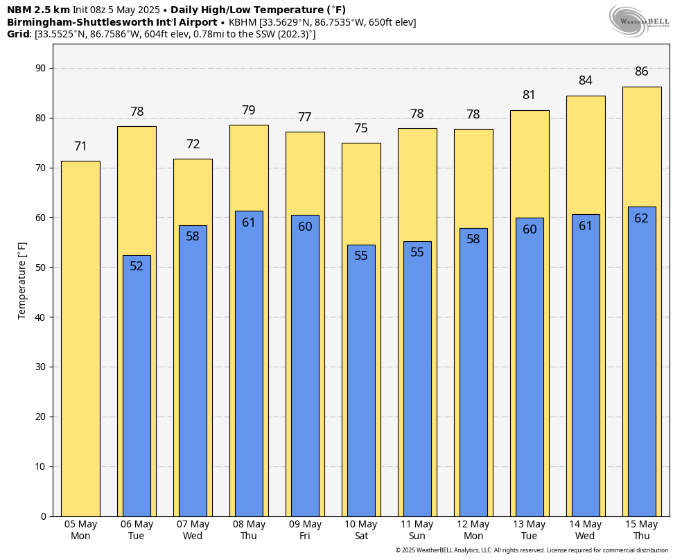
COOL START: Temperatures are in the 40s across much of North/Central Alabama just before daybreak… for some places this will most likely be the last morning with temperatures in the 40s until late September or October. Expect a partly to mostly sunny sky today with only isolated showers over the Tennessee Valley this afternoon and early tonight… highs will be in the 70s.
Tomorrow will dry for most of the state, but a few showers could creep into the southwest counties by late afternoon. The high tomorrow afternoon will be in the 77-82 degree range.
RAIN RETURNS: The latter half of the week will be wet at times. We expect occasional rain Wednesday through Friday as an upper low slowly approaches from the west. Some thunder is possible, but severe storms are not expected. Rain amounts will be in the 1-2 inch range for most of Alabama on these three days, but heavier amounts are possible mainly over the southern part of the state. Highs will remain in the 70s.
THE ALABAMA WEEKEND: The upper low will weaken and continue drifting eastward. Alabama’s weather trends drier, with a partly sunny sky forecast Saturday and Sunday. Any showers should be widely spaced, and mainly over the southern quarter of the state. Highs will be in the 75-80 degree range both days.
And, for now, much of next week looks dry with warmer with highs returning to the 80s Tuesday through Friday. See the video briefing for maps, graphics, and more details.
ON THIS DATE IN 1933: Early in the morning of May 5, 1933, a tornado that was at times a third of a mile wide swept through Bibb and Shelby counties. It carved a track 35 miles long, and killed 20 people as they slept. More than 150 people were injured in Helena, where rescue efforts were hampered by the darkness and the heavy rains that followed the twister. Another tornado the same day killed four people at Demopolis.
ON THIS DATE IN 1995: A supercell thunderstorms brought torrential rains and large hail up to four inches in diameter to Fort Worth, Texas. This storm also struck a local outdoor festival known as the Fort Worth Mayfest. At the time the storm was the costliest hailstorm in the history of the US, causing more than $2 billion in damage.
Look for the next video briefing here by 3:00 this afternoon… enjoy the day!
Category: Alabama's Weather, ALL POSTS, Weather Xtreme Videos
About the Author (Author Profile)
James Spann is one of the most recognized and trusted television meteorologists in the industry. He holds the AMS CCM designation and television seals from the AMS and NWA. He is a past winner of the Broadcast Meteorologist of the Year from both professional organizations.Subscribe
If you enjoyed this article, subscribe to receive more just like it.


