Midday Nowcast: Great Weather Today and Friday; Scattered Showers and Storms Return this Weekend
WARM DAYS, PLEASANT NIGHTS: Highs today are climbing into the mid to upper 80s this afternoon. Tomorrow, cooler and drier air will move into the state with highs falling into the 70s over the northern half of the state, while 80s are expected over South Alabama. Lows will be in the 50s. There have been a few showers over far northern Alabama this morning, but these continue to wind down and overall it will be a dry Thursday and Friday for Alabama.
BIRMINGHAM ALMANAC: For May 22nd, the average high for Birmingham is 83° and the average low is 63°. The record high is 96° set in 1962, while the record low is 42° set in 1993. We average 0.15” of precipitation on this date and the record value is 2.54” set in 1939.
ACROSS THE USA: Severe thunderstorms are possible across parts of the southern Plains today. Large hail is the main threat, along with some damaging winds. A few instances of 2+ inch diameter hail are possible. A storm system moving north along the New England coast will bring heavy rain and gusty winds to the region through Friday.
MEMORIAL DAY WEEKEND: Some changes in the forecast for Saturday and Sunday as we are bringing the chance for showers and storms to the northern two-thirds of Alabama. In fact, the Storm Prediction Center has introduce a “marginal risk” (level 1 of 5) of severe storms Saturday to Alabama.
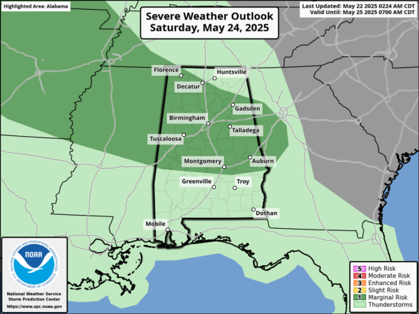
Some storms could reach marginally severe limits during the peak heating of the days, with gusty winds and hail the main threats. Showers and storms remain likely Monday. Highs through the holiday will be in the 80s, while lows will be in the 60s. It will not be a weekend “wash out,” but just know showers and storms will be possible at time all three days this weekend.
NEXT WEEK: For the final week of May, Tuesday and Wednesday will continue to feature the chance for likely showers and storms as a cold front approaches. For the latter half of the week, cooler and drier air will return to Alabama with highs in the 70s and lows possibly in the 50s.
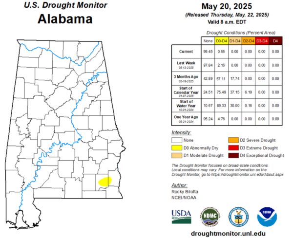
DROUGHT MONITOR: Much of the state is in great shape, but we continue to see 0.55% of the state seeing Abnormally Dry conditions. The only two counties seeing this are Dale and Henry in Southeast Alabama.
WORLD TEMPERATURE EXTREMES: Over the last 24 hours, the highest observation outside the U.S. was 123.3F at Omidieh, Iran. The lowest observation was -110.6F at Vostok, Antarctica.
CONTIGUOUS TEMPERATURE EXTREMES: Over the last 24 hours, the highest observation was 109F at Death Valley, CA. The lowest observation was 17F at Peter Sinks, UT.
Category: Alabama's Weather, ALL POSTS, Social Media
About the Author (Author Profile)
Macon, Georgia Television Chief Meteorologist, Birmingham native, and long time Contributor on AlabamaWX. Stormchaser. I did not choose Weather, it chose Me. College Football Fanatic. @Ryan_StinnetSubscribe
If you enjoyed this article, subscribe to receive more just like it.


