Midday Nowcast: Some Showers and Storms Ahead of Front Dropping South
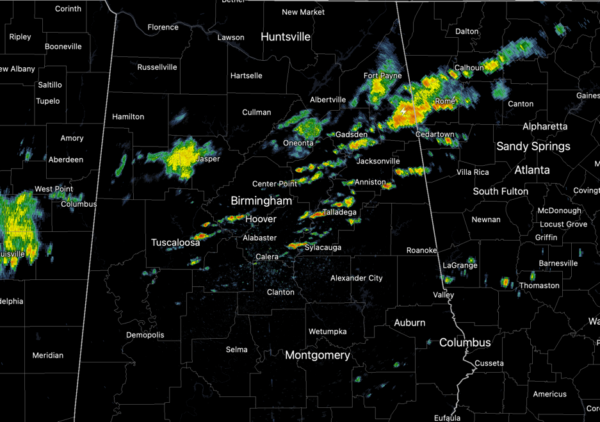
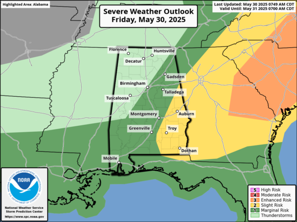
FRONT DROPPING SOUTH: A cold front is pushing through the state currently, and along the front we are seeing showers and storms develop along the front moves through, a few strong storms are possible with gusty winds and small hail, However, the highest threat of severe is across southeastern portions of Alabama, where a level 2 of 5 threat of of severe storms is in place for this afternoon.
Behind the front, drier air is beginning to move into the northern counties by the afternoon where the temperatures will be in the 70s.
BIRMINGHAM ALMANAC: For May 30th, the average high for Birmingham is 85° and the average low is 65°. The record high is 97° set in 1914, while the record low is 41° set in 1984. We average 0.16” of precipitation on this date and the record value is 2.80” set in 1959.
WONDERFUL WEEKEND WEATHER: Dry and pleasant weather for tomorrow and Sunday, finally a mainly rain-free weekend for the state. Humidity levels will be lower; cooler spots over North Alabama should reach the 50s early Saturday morning. Highs will be mostly in the low 80s Saturday, followed by mid 80s Sunday. A few random, pop-up showers are possible late Sunday.
NEXT WEEK: The weather next week will trend drier and hotter as an upper ridge builds across the region. Most days will be dry with afternoon highs approaching the 90 degree mark. For the latter half of the week, we should see scattered afternoon showers and storms could return. Routine early June weather for Alabama.
WORLD TEMPERATURE EXTREMES: Over the last 24 hours, the highest observation outside the U.S. was 119.3F at Al Ahsa, Saudi Arabia. The lowest observation was -86.8F at Dome A, Antarctica.
CONTIGUOUS TEMPERATURE EXTREMES: Over the last 24 hours, the highest observation was 112F at Death Valley, CA. The lowest observation was 28F at Mackay, ID
Category: Alabama's Weather, ALL POSTS, Social Media
About the Author (Author Profile)
Macon, Georgia Television Chief Meteorologist, Birmingham native, and long time Contributor on AlabamaWX. Stormchaser. I did not choose Weather, it chose Me. College Football Fanatic. @Ryan_StinnetSubscribe
If you enjoyed this article, subscribe to receive more just like it.


