Midday Nowcast: Higher Rain Chances for East Alabama Today; Strong Storms Likely Friday and Saturday
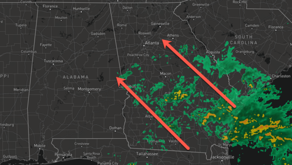
It is a wet Wednesday for some across Alabama today as tropical moisture surges in from the south and east. However, many locations will remain dry with a mix of sun and clouds. Rain chances today are in the 20-50% range, with the higher rain chances over East and South Alabama. Highs today are in the mid to upper 80s. Not much change tomorrow, with widely scattered showers and storms possible.
BIRMINGHAM ALMANAC: For June 4th, the average high for Birmingham is 86° and the average low is 66°. The record high is 98° set in 1899, while the record low is 52° set in 1946. We average 0.16” of precipitation on this date and the record value is 1.56” set in 1982.
STORMS RETURN FRIDAY: The chance for rain and storms increases on Friday as a front approaches from the north. The front, interacting with the tropical air mass in place, means many of us will see rain return to the forecast.

Some strong storms are possible and the Storm Prediction Center has outline the northern half of Alabama in a threat of severe storms for Friday afternoon and evening. Strong storms which develop could produce strong, gusty winds and hail. The tornado threat is very low, but not zero.
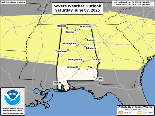
STORMY SATURDAY & SUNDAY: The Storm Prediction Center has already outlined the northern two-thirds of Alabama in a risk of severe storms on Saturday. Very similar to Friday, stronger storms will produce strong, gusty winds and hail. Again, the tornado threat is very low, but never zero. Additionally all storms will produce tropical downpours and frequent lightning. We will maintain the chance of scattered showers and thunderstorms on Sunday. The weekend won’t be a wash-out, and the sun will be out at times. It will warm and very muggy with highs in the 80s. With the moisture-rich air mass in place, some locations could deal with areas of isolated flash flooding.
NEXT WEEK: The weather will be pretty much what we expect in June in Alabama. Partly sunny, warm, humid days with the chance of scattered, mostly afternoon and evening showers and thunderstorm” through the week. Highs remain in the 80s.
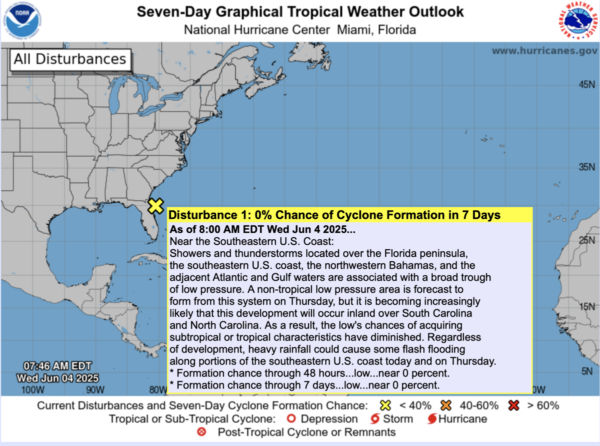
IN THE TROPICS: Near the Southeastern U.S. Coast, showers and thunderstorms located over the Florida peninsula, the southeastern U.S. coast, the northwestern Bahamas, and the adjacent Atlantic and Gulf waters are associated with a broad trough of low pressure. A non-tropical low pressure area is forecast to form from this system on Thursday, but it is becoming increasingly likely that this development will occur inland over South Carolina and North Carolina. As a result, the low’s chances of acquiring subtropical or tropical characteristics have diminished. Regardless of development, heavy rainfall could cause some flash flooding along portions of the southeastern U.S. coast today and on Thursday. Formation chance: near 0 percent. The rest of the Atlantic Basin is quiet for now.
WORLD TEMPERATURE EXTREMES: Over the last 24 hours, the highest observation outside the U.S. was 115.5F at Sibi, Pakistan. The lowest observation was -103.9F at Vostok, Antarctica.
CONTIGUOUS TEMPERATURE EXTREMES: Over the last 24 hours, the highest observation was 109F at Stovepipe Wells and Death Valley, CA. The lowest observation was 19F at Mackay, ID.
Category: Alabama's Weather, ALL POSTS, Social Media
About the Author (Author Profile)
Macon, Georgia Television Chief Meteorologist, Birmingham native, and long time Contributor on AlabamaWX. Stormchaser. I did not choose Weather, it chose Me. College Football Fanatic. @Ryan_StinnetSubscribe
If you enjoyed this article, subscribe to receive more just like it.


