Alabama 811 | Know What's Below.

Archive for March 28th, 2010

F1 Tornadoes Can Kill Too…

F1 Tornadoes Can Kill Too…

| March 28, 2010 @ 10:25 pm | 3 Replies

Hoyt Watts awakened around 5:35 a.m. on the morning of March 29, 1991 in his home on Highway 21 in Munford in Talladega County. It was storming outside. Storming bad. The wind was roaring loudly and lightning was flashing as thunder sounded continuously. He looked out the window and could not believe his eyes. A […]

Read More

Late Afternoon in Alabama–5 o’clock

Late Afternoon in Alabama–5 o’clock

| March 28, 2010 @ 4:57 pm | 4 Replies

Very little going on around the great state of Alabama late this afternoon except some brisk westerly winds. Gusting as high as 25 to 30 mph in many areas and even higher on the ridges. Much drier air spreading across the state. A few isolated light showers linger but, by far, most of the rain […]

Read More

Extra Alabama Notes (Mostly)

Extra Alabama Notes (Mostly)

| March 28, 2010 @ 2:42 pm | Reply

* As that line of showers and thunderstorms moved east across (mainly north and central) Alabama today, there was no formal Severe Thunderstorm Watch. That fit the situation. The Storm Prediction Center had a “slight risk” mainly east of Alabama.. * Only one Severe Thunderstorm Warning during the day today. That was one for West […]

Read More

Sunday Afternoon in Alabama–2 pm

Sunday Afternoon in Alabama–2 pm

| March 28, 2010 @ 2:00 pm | 6 Replies

Almost all of today’s showers and storms have moved east out of Alabama. At 2 pm, the ones that remain were in a line from Clay County in East Central Alabama, northeast across Cleburne County and then into NW Georgia. The ones in Alabama are light to moderate, a few heavy showers. However, the NWS […]

Read More

From NWS, Atlanta

From NWS, Atlanta

| March 28, 2010 @ 1:35 pm | Reply

BULLETIN – EAS ACTIVATION REQUESTED TORNADO WARNING NATIONAL WEATHER SERVICE PEACHTREE CITY GA 220 PM EDT SUN MAR 28 2010 THE NATIONAL WEATHER SERVICE IN PEACHTREE CITY HAS ISSUED A * TORNADO WARNING FOR… WHITFIELD COUNTY IN NORTHWEST GEORGIA * UNTIL 245 PM EDT * AT 218 PM EDT…NATIONAL WEATHER SERVICE DOPPLER RADAR INDICATED A […]

Read More

1 O’clock and All’s Well…

1 O’clock and All’s Well…

| March 28, 2010 @ 12:54 pm | 1 Reply

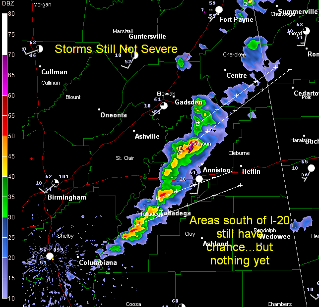
Storms have still shown no sign of becoming severe at this hour. The only real storm right now is north of Anniston. The line of heavy showers extends down through Talladega County. It is moving east at about 20 mph while individual cells are moving ENE at 45 mph. The best chance for severe weather […]

Read More

St. Clair County Storm Strongest…Shelby Cells Growing

St. Clair County Storm Strongest…Shelby Cells Growing

| March 28, 2010 @ 11:31 am | 2 Replies

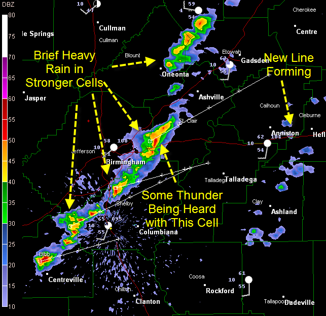
Heard some thunder in past few minutes from cell that extends from west of Odenville to Moody. It will bring brief heavy rain, perhaps small hail and some lightning to much of St. Clair County as it moves ENE. Cells from west of Chelsea to Alabaster to north of Centreville are definitely growing. Areas south […]

Read More

Alabama at 11

Alabama at 11

| March 28, 2010 @ 11:02 am | 1 Reply

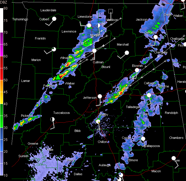
Our line of storms keeps plodding eastward across the state at this hour. It extends from DeKalb County in NE Alabama through Marshall, Blount, Jefferson, western Shelby and then into Bibb County. Ranking the storms this hour. 1. Near Sylvania in DeKalb Countiy. Top to 16,000 feet., (Freezing level is at 8,000 feet.) WIll be […]

Read More

Checking the Alabama Weather Situation at 9:55

Checking the Alabama Weather Situation at 9:55

| March 28, 2010 @ 10:01 am | 3 Replies

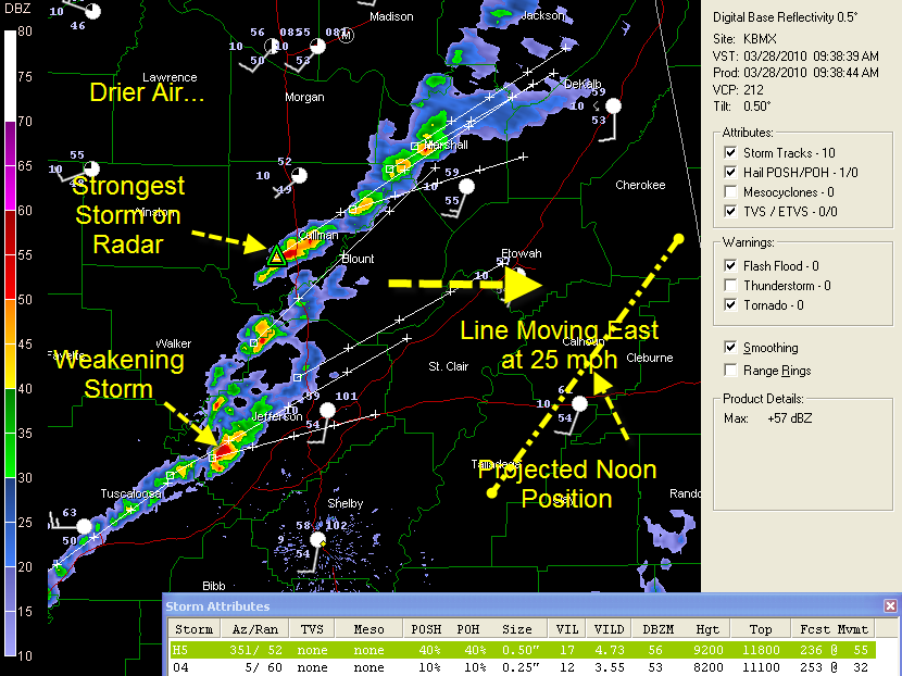
A line of low topped showers and storms continues eastward across Alabama at 25 mph this morning. When I made the graphic ten minutes ago, a storm in Cullman county was the strongest on radar. I t is near Holly Pond and is still putting down decent amount of lightning and maybe small hail. Now […]

Read More

Cullman Warning Expires

Cullman Warning Expires

| March 28, 2010 @ 9:03 am | Reply

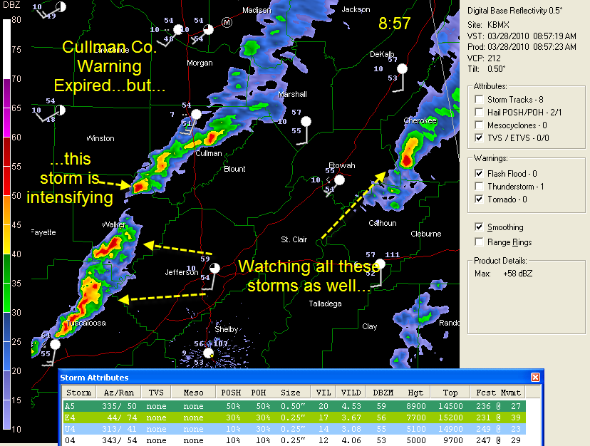
The Cullman County warning has expired. Other storms are of interest across Central Alabama as colder air aloft moves in and some clearing occurs ahead of the line of storms. Storms could continue to go severe until the front arrives this afternoon.

Read More

Severe Thunderstorm Warning – Cullman County

Severe Thunderstorm Warning – Cullman County

| March 28, 2010 @ 8:31 am | 3 Replies

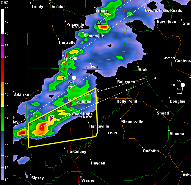
Severe Thunderstorm Warning for Cullman County till 9:00 AM CDT. Storm southwest of Good Hope is getting organized with some rotation and could produce damaging winds to 60 mph or greater. Deputies report heavy rain and lightning in the Trimble area of Cullman County according to Skywatcher Brian Falls who is monitoring scanner traffic.

Read More

Showers and Storms Advancing East

Showers and Storms Advancing East

| March 28, 2010 @ 7:56 am | Reply

The main line of showers and storms is over West Alabama this morning. It extends from Madison to Addison to Carbon Hill to Aliceville. The strongest storm was east of Carbon Hill. It is moving up toward Manchester and Curry and Smith Lake. It probably has small hail to the size of marbles, and is […]

Read More

Some Rain – Cooler – Then Dry & Warm

Some Rain – Cooler – Then Dry & Warm

| March 28, 2010 @ 7:02 am | 2 Replies

The latest edition of the ABC 33/40 Weather Xtreme Video is available in the player below. You can subscribe to the Weather Xtreme Video on iTunes by clicking here. Radar this morning showed a large area of showers and rain moving through Middle Tennessee with some of that rain area moving across the Tennessee River […]

Read More

More Showers and Storms Developing

More Showers and Storms Developing

| March 28, 2010 @ 6:53 am | Reply

Showers and thunderstorms are developing across Central Alabama this morning. Heavy showers and some storms developed in the last 45 minutes near Columbus MS and moved quickly into northern Pickens, Lamar, Fayette and southeastern Marion and Winston Counties in West Alabama. A decent storm was located between Brilliant, Haleyville and Natural Bridge. These storms are […]

Read More