Rain Returns Later This Week Statewide
COOL MORNING: The sky is cloudy over the southwest part of the state early this morning with some patchy light rain, but for North and Central Alabama it is clear and cool. Some early morning temperatures include…
Black Creek 54
Weaver 55
Haleyville 55
Albertville 55
Cullman 56
Fort Payne 56
Good Hope 56
Decatur 57
Huntsville 57
Anniston 58
Talladega 58
Alexander City 58
Muscle Shoals 58
Auburn 59
Birmingham 60
Hueytown 60
Bessemer 61
Tuscaloosa 64
Montgomery 64
Mobile 65
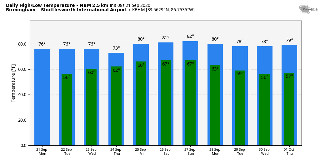
Sunny, pleasant weather continues over the northern half of the state today with a high in the upper 70s… clouds linger over the southern part of the state with some light rain near the coast. Tomorrow will be a partly sunny day with a high in the mid to upper 70s over the northern counties, with clouds hanging tough over South Alabama.
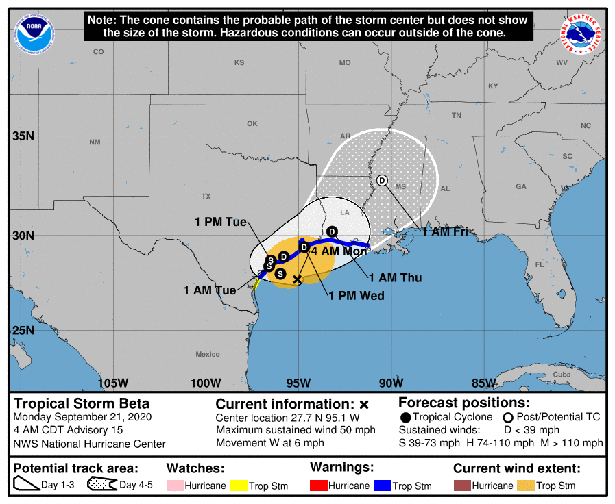
RAIN RETURNS STATEWIDE: Clouds will increase statewide Wednesday, and the rain shield associated with Tropical Storm Beta moves into West Alabama during the day. Rain becomes likely state statewide Wednesday night and Thursday as Beta is forecast to be a remnant low over Mississippi by Thursday night. For now, we do not expect a tornado threat as the air will be cool and stable, and the surface low will be weak.
FRIDAY AND THE WEEKEND: The weather will be cloudy and occasionally wet on these three days as deeper tropical moisture will linger over the state. Look for periods of rain Friday through Sunday with a few thunderstorms possible as well. There will be breaks in the rain, of course, but if you have something planned outdoors (like high school football games Friday night) be ready for rain at times. Humidity levels will be high, and highs will be at or just over 80 degrees each day. Rain amounts Wednesday night through Sunday will be in the 2-4 inch range over North Alabama, and 1-2 inches for the southern half of the state.
NEXT WEEK: Another cool, dry airmass rolls into here Sunday night, and for now next week looks dry with sunny pleasant days and clear cool nights. Highs will be mostly in the 70s, with lows in the 50s. See the Weather Xtreme video for maps, graphics, and more details.
TROPICS: Hurricane Teddy, with winds of 100 mph, will pass just east of Bermuda today before heading for Nova Scotia Wednesday as a post-tropical system. No impact on the U.S. other than rough surf on the east coast.

Tropical Storm Beta will hug the Texas and Louisiana coasts today through Wednesday, winding up in Mississippi as remnant low Thursday. The main impact will be heavy rain; rain amounts of 4-6 inches are possible for places like Houston, Galveston, Port Arthur, and Lake Charles. A few isolated waterspouts or brief tornadoes can’t be ruled out.
Elsewhere in the tropics, Wilfred has dissipated in the open Atlantic, and the “ghost of Paulette” in the northeast Atlantic has some chance of regenerating. But no systems other than Beta are close to the U.S.
ON THIS DATE IN 1989: Just before midnight, Hugo made landfall on Isle of Palms, South Carolina as a Category 4 hurricane. This storm brought strong winds to many areas of South Carolina. In Downtown Charleston, sustained winds of 87 mph were reported; along with gusts of 108 mph. Hugo was the strongest hurricane to landfall on the continental U.S. in two decades. Along the coast of South Carolina, Hugo set new records for storm surge heights along the U.S. East Coast, reaching 20.2 feet near McClellanville, South Carolina. The surge and winds wrought extensive damage across South Carolina’s barrier islands, destroying many beachfront homes and other coastal installations. Hugo’s northward acceleration at landfall led to unusually large and significant impacts to forests between South Carolina and Virginia, inflicting further damage to property; in South Carolina alone the loss of timber was estimated at $1.04 billion. Flood and wind impacts followed Hugo across much of the eastern United States and into eastern Canada.
BEACH FORECAST: Click here to see the AlabamaWx Beach Forecast Center page.
WEATHER BRAINS: Don’t forget you can listen to our weekly 90 minute show anytime on your favorite podcast app. This is the show all about weather featuring many familiar voices, including our meteorologists here at ABC 33/40.
CONNECT: You can find me on all of the major social networks…
Facebook
Twitter
Instagram
Pinterest
Snapchat: spannwx
Look for the next Weather Xtreme video here by 4:00 this afternoon… enjoy the day!
Category: Alabama's Weather, ALL POSTS, Weather Xtreme Videos
About the Author (Author Profile)
James Spann is one of the most recognized and trusted television meteorologists in the industry. He holds the AMS CCM designation and television seals from the AMS and NWA. He is a past winner of the Broadcast Meteorologist of the Year from both professional organizations.Subscribe
If you enjoyed this article, subscribe to receive more just like it.


