More Strong/Severe Storms Likely Later Today
ANOTHER ACTIVE DAY AHEAD: Alabama is rain-free at sunrise, but another round of strong to severe thunderstorms is likely later today and tonight. SPC has defined an “enhanced risk” (level 3/5) of severe thunderstorms for much of Northeast Alabama, for Birmingham and points north and east. A “slight risk” (level 2/5) extends down to Tuscaloosa, Montgomery, and Eufaula, and a “marginal risk” (level 1/5) covers much of the rest of South Alabama.
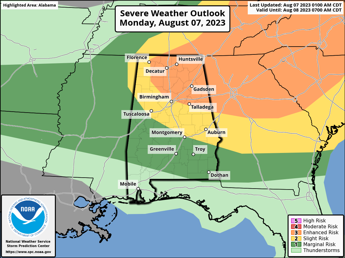
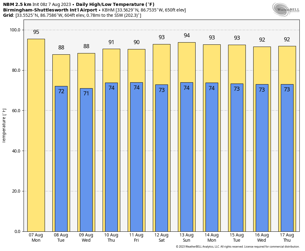
Like recent days, the main issue is damaging straight line winds. The core risk of severe thunderstorms will come from roughly noon to 9:00 p.m. We encourage you to pay attention to severe thunderstorm warnings since a number of them will likely be needed. Temperatures will likely reach the low to mid 90s before the storms arrive.
TOMORROW/WEDNESDAY: Heat levels will drop in the wake of a surface front; temperatures will likely remain below 90 degrees over the northern half of the state. Showers and storms will be around, and SPC has defined level 1/2 risks for parts of the state both days. Most, but not all of the showers and storms will come in the noon to midnight window. The chance of any one spot seeing rain both days is 55/65 percent.
THURSDAY THROUGH THE WEEKEND: For now it looks like some typical August weather for the state with a mix of sun and clouds daily along with “scattered, mostly afternoon and evening showers and thunderstorms”. Highs will be right at seasonal averages, in the low 90s.
We see no reason for any major changes next week. Partly sunny days with an afternoon thunderstorm possible in spots; highs generally in the low 90s. See the video briefing for maps, graphics, and more details.
TROPICS: The Atlantic basin remains amazingly quiet for August, and tropical storm formation is not expected for the next seven days.
YESTERDAY: Hundreds of trees were blown down across Alabama yesterday by severe thunderstorms with strong winds. At one point over 70,000 people had no power; that number is down to around 4,000 at sunrise this morning. Wind damage was reported in at least two dozen counties, mostly over the northern half of the state.
ON THIS DATE IN 1924: A tornado caused estimated F4 damage moved southeast from south of Osseo, WI to Black River Falls, WI. One person was killed as a home was leveled and a boy was killed running to the storm cellar near the start of the path. Two people died as farm homes were swept away near the northeast edge of Black River Falls.
ON THIS DATE IN 1940: A hurricane moved ashore near Sabine Pass, Texas with winds of 100 mph. Nineteen official weather stations in both Texas and Louisiana recorded record-level 24-hour rainfall totals for the month of August as a result of the slow-moving hurricane. Property, livestock, and crops–especially cotton, corn, and pecan crops–were heavily damaged. Entire ecosystems were also altered by the rainfall.
ON THIS DATE IN 1980: Hurricane Allen bottomed out at 899 millibars (26.55 inches of mercury) while moving through the Yucatan Channel in the southeastern part of the Gulf of Mexico. Allen was the second lowest pressure ever recorded in the Western Hemisphere up to that time. Allen’s winds at the time were sustained at 190 mph.
Look for the next video briefing here by 3:00 this afternoon… enjoy the day!
Category: Alabama's Weather, ALL POSTS, Weather Xtreme Videos
About the Author (Author Profile)
James Spann is one of the most recognized and trusted television meteorologists in the industry. He holds the AMS CCM designation and television seals from the AMS and NWA. He is a past winner of the Broadcast Meteorologist of the Year from both professional organizations.Subscribe
If you enjoyed this article, subscribe to receive more just like it.


