Windy/ Warm Day Tomorrow; Colder Wednesday With Some Rain
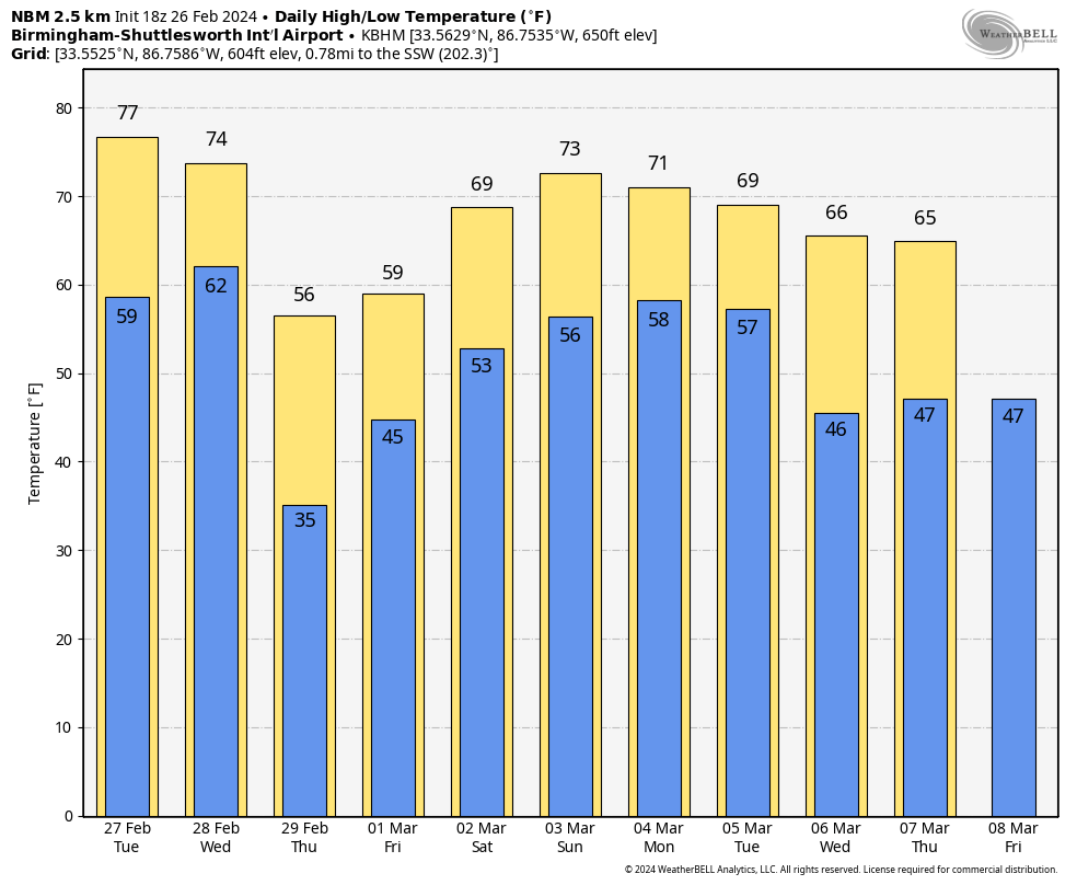
LIKE SPRING: With a mostly sunny sky, temperatures are in the 70s across Alabama this afternoon. Clouds will increase tonight, and a few isolated showers are possible tomorrow morning over the northern third of the state. Some sun is possible tomorrow afternoon, and we project highs in the 75-82 degree range. It will be the warmest day so far this year.
Winds will ramp up tomorrow afternoon and tomorrow night, averaging 15-30 mph, with possible gusts to 40 mph in spots. These are gradient winds, not related to thunderstorms.
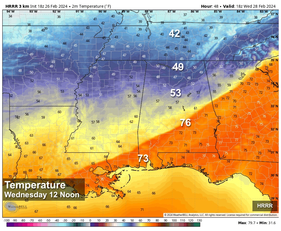
WEDNESDAY: A cold front will push into Alabama, bringing a band of showers and possibly a thunderstorm or two; there is no risk of severe storms. There will be a sharp thermal contrast across the state due to the front…temperatures will settle into the 40s over the northern third of the state, while South Alabama will see another day with highs in the 70s. For some places across the central counties, temperatures will rise to near 70 by midday, but then they fall through the 60s and 50s during the afternoon.
Gradient winds during the day Wednesday will gust to 25/30 mph at times as cold air rushes into the state on the back side of thew front.
THURSDAY/FRIDAY: Thursday will be a cool, dry day for the state with highs in the 50s over North Alabama, with 60s to the south. Then, a wave of low pressure will bring rain back to the state on Friday. It will be a cool rain with temperatures in the 50s.
THE ALABAMA WEEKEND: A pool of moisture will stay in place. The sky will be mostly cloudy, and a few scattered showers are possible both days. Nothing too heavy or widespread, and the weather turns warmer again with highs mostly in the upper 60s Saturday, followed by low 70s Sunday.
NEXT WEEK: A few scattered showers remain possible Monday… showers and storms are more likely late Monday night into Tuesday ahead of another cold front. A few strong storms will be possible, but for now the risk of severe storms looks low with the best dynamic forcing to the north. Drier air returns Wednesday and Thursday with highs in the 60s. See the video briefing for maps, graphics, and more details.
ON THIS DATE IN 1972: The Buffalo Creek disaster occurred in the Buffalo Creek Hollow of Logan County in West Virginia. A coal slag dam on the Middle Fork of Buffalo Creek burst, sending a fifty-foot wall of water down a narrow valley killing 125 persons and causing 51 million dollars in damage. Three days of rain atop a six-inch snow cover caused the dam to break.
ON THIS DATE IN 2008: A derecho moved through parts of Central Alabama during the pre-dawn hours. Although there were some sporadic reports of light tree damage and small hail west of Interstate 65, a more intense and widespread swath of damage started in southern Jefferson and northern Shelby Counties between 3:30 am and 4:00 am. From there, the damage swath moved eastward, roughly parallel to Interstate 20, reaching the Georgia border by 5:00 am. Thunderstorm wind gusts estimated at 60 to 70 mph were widespread in this damage swath, with occasional hurricane force peak wind gusts, estimated just over 100 mph in some areas.
EF-1 tornadoes touched down at Highland Lakes in northern Shelby County, and at Leeds and Pell City.
Look for the next video briefing here by 6:00 a.m. tomorrow…
Category: Alabama's Weather, ALL POSTS, Weather Xtreme Videos
About the Author (Author Profile)
James Spann is one of the most recognized and trusted television meteorologists in the industry. He holds the AMS CCM designation and television seals from the AMS and NWA. He is a past winner of the Broadcast Meteorologist of the Year from both professional organizations.Subscribe
If you enjoyed this article, subscribe to receive more just like it.


