Midday Nowcast: Flood Watch and Some Strong Storms Possible Tomorrow
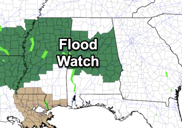
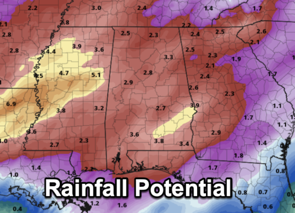
FLOOD WATCH: As expected, with the anticipated upcoming rainfall, most of North/Central Alabama is now included in a flood watch. Rainfall potential between now and Thursday will be in the 2-4 inch range, with isolated higher amounts. We could see flash flooding and flooding issues in the coming days, plus rivers and stream could see much higher flows.
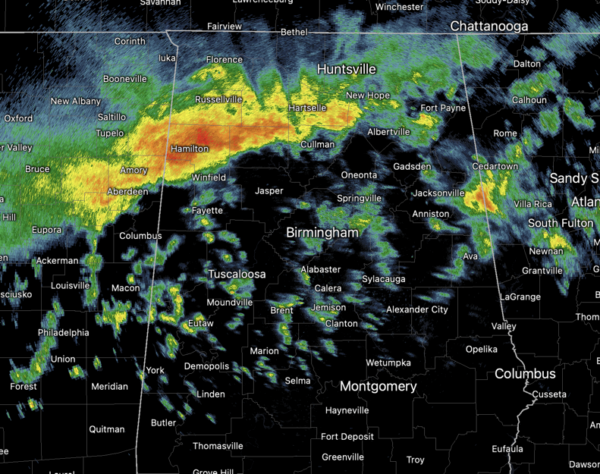
For today, we are seeing clouds with areas of rain and storms. The main area of rain and storms will remain over the northern half of the state, with more scattered activity across southern counties of the state.Temperatures are cooler today with highs in the upper 60s and lower 70s.
BIRMINGHAM ALMANAC: For April 8th, the average high for Birmingham is 74° and the average low is 50°. The record high is 89° set in 2011, while the record low is 30° set in 2000. We average 0.18” of precipitation on this date, and the record value is 1.52” set in 2021.
STORM THREAT WEDNESDAY: Some strong to severe storms are in the forecast and the Storm Prediction Center has all of the state in a risk of severe storms. This is an aggressive outlook for this event, but a “moderate risk” (level 4/5) has been issued for most of South Mississippi, Southeast Louisiana, and portions of Southwest Alabama, south and west of a line from York to Sweet Water to Jackson to Saraland. An “enhanced risk” (level 3/5) of severe thunderstorms extends as far north and east as Sulligent to Oak Grove to Montgomery to Troy to Dothan. A “slight risk” (level 2/5) covers pretty much the rest of the state including the Birmingham Metro, The Shoals, Huntsville, Gadsden, Anniston, and Auburn.
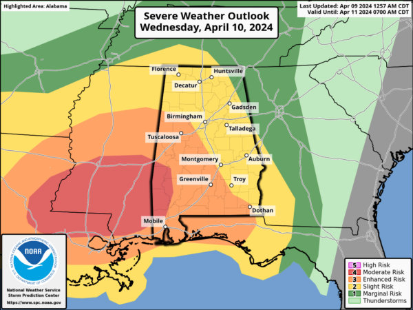
As always, it is important to not get caught up on the colors on the maps, the key take away is that all of Alabama has the potential for severe storms. Damaging winds and tornadoes can occur in a “marginal risk” just like they can in a “moderate risk”. The core threat for severe storms with this event will come during the afternoon, evening, and into the overnight hours. For now, it looks to be 1PM-11PM tomorrow.
This is a very dynamic weather system, but with poor thermodynamic fields. Basically very little surface based instability. A large, rain cooled airmass should limit the overall severe weather threat for Alabama. Having said that, we have to watch any weather system like this closely in April, and a few severe storms can’t be ruled out, especially near the Gulf Coast where there is a chance of higher instability. But clearly the main concern is heavy rain and flooding potential.
THURSDAY/FRIDAY: Thursday will be a mostly cloudy, day with some risk of lingering showers over the northern half of the state. It will be cooler and breezy, and temperatures will struggle to climb out of the 60s. Friday will feature tons of sunshine and highs near 70°.
WEEKEND & NEXT WEEK: The weekend will be warm and dry with lots of sun Saturday and Sunday along with afternoon highs around 80°. Lows will be in the 40s and 50s. It looks like much of the week will stay warm and dry with highs in the low to mid 80s on a daily basis. Some rain is possible toward the end of the week.
BEACH FORECAST CENTER: Get the latest weather and rip current forecasts for the beaches from Fort Morgan to Panama City on our Beach Forecast Center page. There, you can select the forecast of the region that you are interested in visiting.
WORLD TEMPERATURE EXTREMES: Over the last 24 hours, the highest observation outside the U.S. was 113.4F at Kayes, Mali. The lowest observation was -101.7F at Concordia, Antarctica.
CONTIGUOUS TEMPERATURE EXTREMES: Over the last 24 hours, the highest observation was 97F at Rio Grande Village, TX. The lowest observation was 0F at Peter Sinks, UT.
Category: Alabama's Weather, ALL POSTS
About the Author (Author Profile)
Macon, Georgia Television Chief Meteorologist, Birmingham native, and long time Contributor on AlabamaWX. Stormchaser. I did not choose Weather, it chose Me. College Football Fanatic. @Ryan_StinnetSubscribe
If you enjoyed this article, subscribe to receive more just like it.


