Midday Nowcast: Warm and Muggy; Isolated Severe Storms Possible Later Today
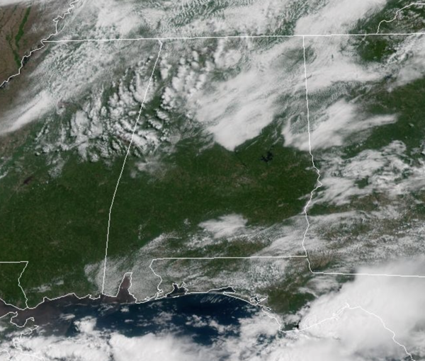
WEATHER HODGEPODGE: Morning fog has given way to midday sun across the state. This afternoon, the warm temperatures and muggy conditions will allow for some thunderstorms across Alabama. Most locations will remain dry today, but where the storms develop this afternoon and evening, they will pack a punch, and could become severe. All of Alabama is included in a risk of severe weather today, with a level 2 of 5 of severe storms along and north of Interstate 20.
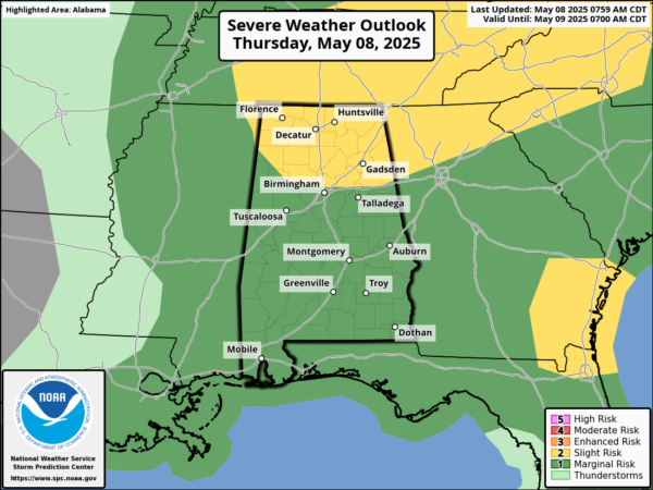
Again, storm coverage will be isolated in nature, but storms will be capable of producing gusty winds and hail, and there is a non-zero tornado threat across North Alabama. Of course in addition to the severe threat, all storms which develop will produce frequent and dangerous lightning as well as very heavy rainfall, which could allow for some areas of isolated flash flooding. Highs today will be surging into the 80s for much of Alabama.
BIRMINGHAM ALMANAC: For May 8th, the average high for Birmingham is 80° and the average low is 59°. The record high is 92° set in 1986, while the record low is 41° set in 1960. We average 0.16” of precipitation on this date and the record value is 2.92” set in 1969.
TOMORROW AND THE WEEKEND: The upper low will remain the main player in our weather, along with a surface low along the Gulf Coast, and these we will keep occasional rain and storms in the forecast tomorrow and both days this weekend. A few strong storms are possible, but the severe weather threat is very low. Highs will be in the mid to upper 70s. Additional rain amounts through Sunday will be in the 1-2 inch range for most of Alabama, but heavier amounts are possible mainly over the southern part of the state, where some spots could see 3-4 inches.
NEXT WEEK: The week looks to start off with continued showers in the forecast at least for Monday and Tuesday. Then the weather will trend drier and warmer over the latter half of next week as an upper ridge builds; it looks like many locations by the end of the week will see highs approaching the lower 90s.
WORLD TEMPERATURE EXTREMES: Over the last 24 hours, the highest observation outside the U.S. was 114.6F at Joba, Oman. The lowest observation was -95.1F at Dome C, Antarctica.
CONTIGUOUS TEMPERATURE EXTREMES: Over the last 24 hours, the highest observation was 99F at Faith Ranch, TX. The lowest observation was 15F at Angel Fire, NM.
Category: Alabama's Weather, ALL POSTS, Social Media
About the Author (Author Profile)
Macon, Georgia Television Chief Meteorologist, Birmingham native, and long time Contributor on AlabamaWX. Stormchaser. I did not choose Weather, it chose Me. College Football Fanatic. @Ryan_StinnetSubscribe
If you enjoyed this article, subscribe to receive more just like it.


