Midday Nowcast: More Showers and Storms Today; Trending Drier and Hotter Rest of Week
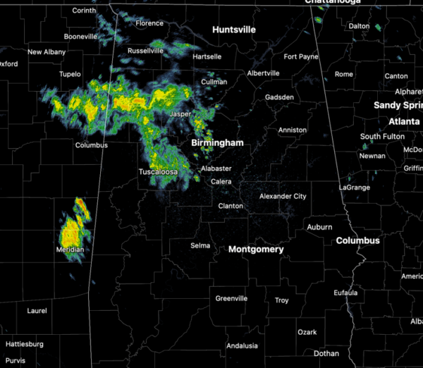
SUN, CLOUDS, RAIN, STRONG STORMS?: The upper low is finally on the move and it will be crossing through North Alabama today. As It does, the warm and muggy air at the surface, and the colder air aloft associated with the low, is allowing showers and storms to develop across Alabama. A few stronger storms are possible this afternoon and evening with gusty winds and hail and we cannot rule out a severe thunderstorm warning or two later today.

Not every location will see the rain and storms, and highs today will be in the mid to upper 70s for the northern half of the state. Rain chances are lower across South Alabama and highs down there will be in the 80s.
BIRMINGHAM ALMANAC: For May 13th, the average high for Birmingham is 81° and the average low is 60°. The record high is 95° set in 1962, while the record low is 38° set in 1960. We average 0.15” of precipitation on this date and the record value is 3.81” set in 1918.
FINALLY A CHANCE TO DRY OUT: The upper low continues to pull away off towards the northeast tomorrow, meaning rain chances will decrease. Most of the state will be dry, but we will still need to mention the chance for scattered showers and storms across northeastern portions of the state. Expect a mix of sun and clouds with highs returning to the mid-80s. Thursday will be mainly sunny and almost hot with highs in the upper 80s. Friday will be a near repeat of Thursday, but a few showers and storms could drop into North Alabama Friday night ahead of a cold front.
WEEKEND WEATHER: Some rain and storms are possible at times both days this weekend as the cold front sinks south into the state. It will not be as wet as this past weekend, but still the umbrella may be needed at times. We should see a mix of sun and clouds both days with highs in the mid to upper 80s. Very warm and muggy weather for all of Alabama.
NEXT WEEK: It looks like we transition into the standard summer pattern next week with warm and muggy weather with highs in the 80s. For now, no big ticket weather system for Alabama, but each days will feature those random, garden variety, scattered afternoon showers and thunderstorms on a daily basis.
WORLD TEMPERATURE EXTREMES: Over the last 24 hours, the highest observation outside the U.S. was 115.7F at In Guezzam, Algeria. The lowest observation was -103.2F at Concordia, Antarctica.
CONTIGUOUS TEMPERATURE EXTREMES: Over the last 24 hours, the highest observation was 105F at Rio Grande Village, TX. The lowest observation was 25F at Mount Washington, NH.
Category: Alabama's Weather, ALL POSTS, Social Media
About the Author (Author Profile)
Macon, Georgia Television Chief Meteorologist, Birmingham native, and long time Contributor on AlabamaWX. Stormchaser. I did not choose Weather, it chose Me. College Football Fanatic. @Ryan_StinnetSubscribe
If you enjoyed this article, subscribe to receive more just like it.


