Strong/Severe Storms For North/Central Alabama Tomorrow Afternoon
RADAR CHECK: We have a classic case of random, scattered showers and thunderstorms across the northern half of Alabama this afternoon… the weather is mostly dry over the southern counties with only isolated showers. A few thunderstorms are producing gusty winds and small hail; scattered showers and storms will end after sunset.
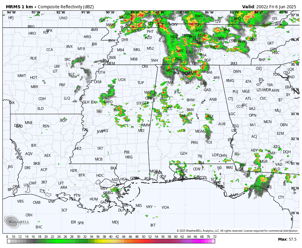
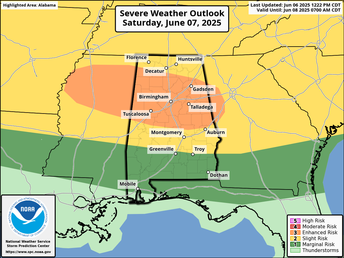
THE WEEKEND: While tomorrow morning will be generally dry, the high resolution models continue to up on the idea of an organized area of thunderstorms moving through the northern half of Alabama with potential for strong (potentially damaging) winds and hail. This mass of storms will sweep through between 1 and 7 p.m… winds could be strong enough in spots to bring down trees and power lines. If you have anything planned outdoors tomorrow afternoon be sure and pay attention to severe thunderstorm warnings.
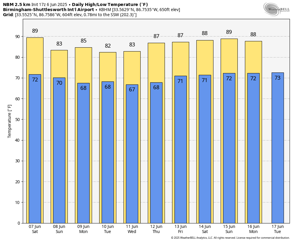
Then, on Sunday, the sun will be out at times, but scattered showers and storms remain possible. Highest risk of showers and storms will be over the northern 2/3 of the state, and temperatures reach the mid 80s.
SPC has defined a risk of severe thunderstorms for much of North/Central Alabama on a daily basis through Sunday due to the wind/hail potential. Parts of North/Central Alabama are in a level 3/5 “enhanced risk” for tomorrow afternoon.
NEXT WEEK: A very humid airmass will stay parked across the Deep South, meaning the risk of scattered, mostly afternoon and evening showers and thunderstorms on a daily basis. Otherwise, expect partly sunny days with highs in the 80s. See the video briefing for maps, graphics, and more details.
TROPICS: The Atlantic basin is quiet; tropical storm/hurricane formation is not expected at least for the next seven days.
ON THIS DATE IN 1816: The temperature reached 92 degrees at Salem, Massachusetts during an early heat wave, but then plunged 49 degrees in 24 hours to commence the famous “year without a summer.” Snow fell near Quebec City, Quebec Canada from the 6th through the 10th and accumulated up to a foot with “drifts reaching the axle trees of carriages.”
ON THIS DATE IN 1944: A strong system approaching Europe on June 4, 1944, ended up delaying the original invasion of northern France on June 5. There were even disagreements in the forecast between American and British forecasters. Ultimately, Group Capt, James Stagg of the United Kingdom’s Supreme Headquarters, Allied Expeditionary Force, was the one who persuaded General Dwight D. Eisenhower to change the date of the invasion to June 6 based on weather observations from a ship in the Atlantic.
Look for my next video briefing here by 6:00 a.m. Monday… enjoy the weekend!
Category: Alabama's Weather, ALL POSTS, Weather Xtreme Videos
About the Author (Author Profile)
James Spann is one of the most recognized and trusted television meteorologists in the industry. He holds the AMS CCM designation and television seals from the AMS and NWA. He is a past winner of the Broadcast Meteorologist of the Year from both professional organizations.Subscribe
If you enjoyed this article, subscribe to receive more just like it.


